When giant kelp first brought Byrnes and Cavanaugh together at UCSB, their work was largely California-focused. The data they collected from the LTER study sites off Santa Barbara became a tremendous resource for kelp researchers. But that work covered four discrete locations for a species found all over the world.
Giant kelp can grow anywhere there are cold, shallow, nutrient-rich waters and a rocky seafloor. Conditions for kelp growth have historically been ideal along the west coast of North America, as well as Chile, Peru, the Falkland Islands, South Africa, and around Australia, New Zealand, and the sub-Antarctic islands.
More and more often these days, though, the conditions are less ideal. Climate change has brought a trifecta of kelp scourges: warmer waters with fewer nutrients; new invasive species; and severe storms.
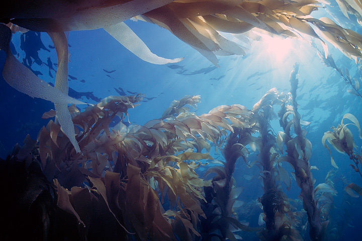
Given the right balance of conditions, giant kelp can grow as much as 50 centimeters (1.6 feet) per day. (Photograph © Phillip Colla / Oceanlight.com)
After a recent meeting on kelp forests and climate change, Byrnes, Cavanaugh, and other colleagues set out to consolidate all of the available kelp forest data from around the world. They wanted to take a step toward understanding how climate change is affecting kelp globally, but they quickly discovered they had a sparse patchwork of information.
Byrnes was struck with a thought. They had used Landsat to expand their studies across time, so why not use Landsat to expand their studies around the world? Could Landsat be used to establish global trends in kelp forest extent? The answer was yes, but the problem was eyeballs.
Unlike research on terrestrial vegetation—which uses Landsat data and powerful computer processing arrays to make worldwide calculations—distinguishing kelp forests requires manual interpretation. While kelp forests pop out to the human eye in near-infrared imagery, computers looking at the data numerically can confuse kelp patches with land vegetation. Programs and coded logic that separate aquatic vegetation from land vegetation can be confounded by things like clouds, sunglint, and sea foam.
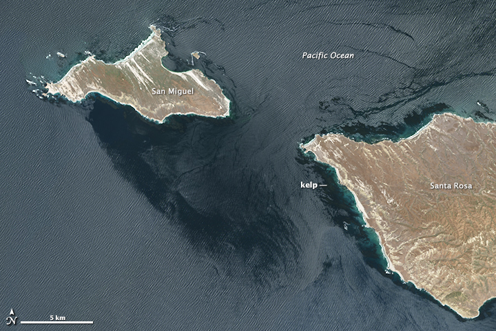
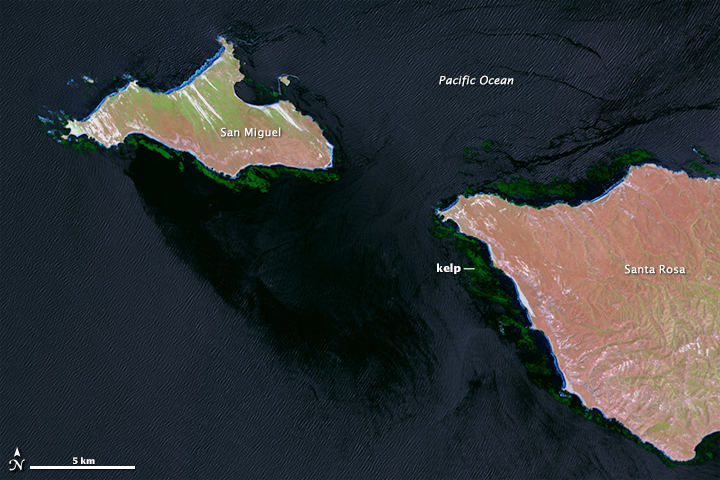
Natural color (top) and near-infrared (bottom) images from Landsat 8 show the kelp-rich waters around California’s Channel Islands. Clouds, sunglint, and sea foam make it difficult for computer programs to detect the location of forests. So far, human eyes work better. (NASA Earth Observatory image by Mike Taylor and Jesse Allen, using Landsat data from the U.S. Geological Survey)
“I’ve spent many, many years staring at satellite imagery trying to come up with new ways to extract the kelp signal from that imagery, and it is very time and work intensive,” said Cavanaugh, now based at the University of California–Los Angeles. “But automated classification methods just don’t produce acceptable levels of accuracy yet.”
Byrnes, now based at the University of Massachusetts–Boston, realized that the best way to study global kelp changes was to turn to citizen scientists. Byrnes and Cavanaugh put together a science team and joined with Zooniverse, a group that connects professional scientists with citizen scientists in order to help analyze large amounts of data. The result was the Floating Forests project.
