The Earth Observatory has published its last Image of the Day on this website. Please join us on our new home at science.nasa.gov/earth/earth-observatory.
The Two Faces of Nitrogen: Nutrient or Nemesis |
|||
“The main problem with nitrogen,” says Acker, “is that too much is definitely not a good thing, particularly for the aquatic environment.” Water running off farm fields and neighborhood lawns carries nitrogen with it, and treatment plants rarely remove all of the excess nitrogen from wastewater before returning it to the flow. The problems are worse for treatment plants that have outdated technology, or that are operating over capacity. Human wastewater isn’t the only nitrogen waste problem for the Chesapeake Bay; concentrated production of pork and chicken creates huge volumes of nitrogen-rich manure, and some of that nitrogen invariably ends up in the Bay. |
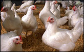
One source of excess nitrogen in the Chesapeake Bay is chicken manure. Animal waste, fertilizers, and incompletely treated sewage deliver more nutrients to the Bay than the native ecosystem can handle. (Photograph courtesy USDA Agricultural Research Service) |
For plants, nitrogen is an indispensable nutrient. As any homeowner in search of a lush green lawn knows, fertilizing with nitrogen enhances the thickness and greenness of the grass. Nitrogen fertilizers allow a smaller number of farmers to produce the crops that feed the rest of the human population. Unfortunately, explains Acker, excess nitrogen in the water makes algae and other single-celled plants (phytoplankton) grow excessively. As the excess algae die, bacteria that decompose the plant matter may use up virtually all the dissolved oxygen in the water, creating bottom-hugging, low-oxygen “dead zones.” In summer 2004, a dead zone spanned more than a third of the Chesapeake Bay floor. Around the world, similar dead zones are occurring with increasing frequency in estuaries and near the mouths of major rivers. Immersed in the SubjectAcker has been involved with the Chesapeake Bay ever since moving to the Chesapeake watershed from the shore of another bay—Tampa Bay, where he studied chemical oceanography at the University of South Florida’s Department (now College) of Marine Science. His first studies of the Bay were about the influence of acid rain on Bay chemistry and biology. Since 1996, Acker has been working as a data support scientist at NASA’s Goddard Space Flight Center. Throughout his career as a data support scientist, Acker has helped oceanographers in 80 different countries to get and use remote-sensing data for oceanographic research. |
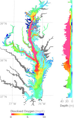
The decay of algae and other phytoplankton lowers the levels of dissolved oxygen in the Bay—creating dead zones where most animals cannot survive. This map shows measurements of dissolved oxygen for July 15–30, 2004. The graph on the right shows dissolved oxygen levels between the surface and a depth of 40 meters through the center of the Bay. Orange and red colors correspond to the dead zone. (Map copyright Chesapeake Bay Program) |
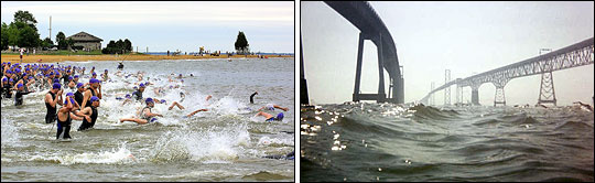
While living in Virginia and Maryland, Acker also became familiar with the Chesapeake Bay in a more direct fashion—by competing in a local event called the Bay Bridge Swim, a 4.5-mile crossing of the Bay. As an oceanographer, a resident of the Bay watershed, a researcher on the chemistry of streams and oceans, and even an occasional semi-aquatic part of the Bay ecosystem, Acker is interested in the vital importance of estuaries such as the Chesapeake Bay. At his job, Acker works to increase the awareness among oceanographers of how to use ocean-color data to investigate the oceans. Those two interests intersected when his colleagues at the data center developed a new data analysis tool they called “Giovanni.” |
|||
 | |||
Giovanni is a Web-based software program that helps scientists who aren’t experts in remote sensing to overcome some of the technological and practical hurdles of working with satellite data. Analyzing year-to-year changes in the plant productivity of coastal waters was just the type of project its designers had envisioned for Giovanni.
|
Jim Acker has first-hand experience in the Chesapeake: he has participated in the annual Great Chesapeake Bay Swim. (Photographs copyright Jeff Hall (left) and Cheryl Wagner (right). | ||
