What’s wrong with the forecast models? |
|||
Uccellini admits that there was some uncertainty in the minds of meteorologists as to what path the storm would take. He says the National Weather Service could have emphasized that uncertainty more in its forecasts. But forecasters have become spoiled by the increasing accuracy of computer models and nowadays they rely upon them quite heavily. Forecasters are reluctant to publicly present weather scenarios that contradict the models. It is far safer for one’s professional reputation, for instance, to follow the mainstream rather than to be the lone voice "crying wolf." |
|||
 | |||
"Forecasters know the models aren’t perfect," Uccellini says. "There should be some way to present alternate scenarios without creating a panic." Jones adds, "My feeling is that most numerical models have gotten so good
in the two- to three-day timeframe, most meteorologists thought the storm would
move out to sea [having little impact on land]. But 12 or 24 hours before it
hit, there may have been some indication from satellite imagery that the storm
wasn’t behaving as the models were forecasting." |
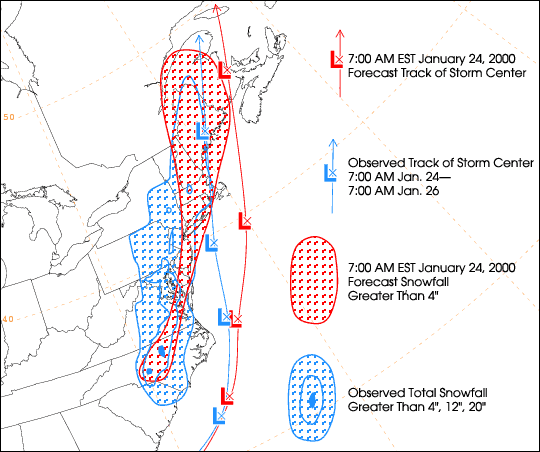
The map above shows the difference between the storm’s observed behavior and the forecast made 24 hours before. The storm travelled much closer to shore than was predicted, and dropped a lot more snow. [Map courtesy Brett McDonald, National Centers for Environmental Prediction (NCEP)] | ||
Jones advises forecasters to use the entire suite of meteorological tools at their disposal. He says satellite imagery is critical to the science of meteorology today and in the future. He also advocates the use of surface-based measurements, upper-air balloons, aircraft measurements and even radar. Perhaps paying closer attention to these latter data sources would have enabled forecasters to predict more accurately the blizzard’s course. The fact remains, however, that predicting the weather days in advance is inherently prone to error. Uccellini notes that even with all their numerical models and all their measurements and satellite observations, meteorologists still cannot obtain data on every point in the atmosphere and ocean. "Ocean and atmosphere are two fluids," he explains, "and as they interact they go through many non-linear dynamics that produce our weather. (Some of these ocean-atmosphere dynamics are discussed in-depth in the Ocean & Climate fact sheet.) The best you can do is estimate and interpolate what’s going on there. In so doing, you’re going to introduce errors within the models. Over time, those errors grow until eventually they render the model useless." For this reason, says Uccellini, the limit for weather forecasts is set at 14 days. The errors within the observations and models are such that after 14 days they have "snowballed" until the model is useless for predicting any specific event. Jones cites the Chaos Theory, stating that scientists still don’t understand the ways that small-scale events can end up having large-scale effects. "It goes back to the question of whether the flap of a butterfly’s wings in Brazil could lead to a chain of events that causes a tornado in Texas," he says. "The models would never forecast those types of chain events...perhaps one day, but not now." |
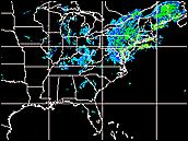 After pounding North Carolina on the 24th, bands of intense precipitation remained inland on the 25th, instead of moving out to sea. During the height of the storm, snow was accumulating on the ground at more than an inch per hour. (Image based on data from NOAA)
View: low quality animation (.85 MB) | ||
