

 | |||
|
Earth scientists who work with satellite data often fall into one of two categories. Some are driven by questions that can only be answered by viewing Earth on the planetary scale. How fast are people clearing tropical forests? Is the Earth more or less cloudy today than it was 20 years ago? For these scientists, satellite data are stepping stones. In the second category are scientists who are driven to invent—the technophiles, the space junkies. For these scientists, the thrill is in figuring out how to observe things from space that no one has been able to observe before. Perfecting the picture of Earth that satellites provide is an end in itself. |
|||
Tropical climatologist Rong Fu, of Georgia Institute of Technology, is more of the former. Remote-sensing scientist Ranga Myneni, of Boston University, is more of the latter. Fu’s research group is trying to understand what causes the length and timing of the rainy season in South America to change from year to year. Myneni’s makes global estimates of leaf area from data collected by NASA’s Terra and Aqua satellites. |
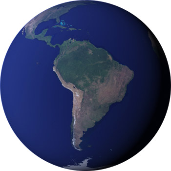
Scientists use satellite data to gain a long-term, wide-scale view of the Earth not possible from the surface. Recent research with these data is revealing unexpected seasonal changes of vegetation in the Amazon—changes that might explain puzzling questions about the onset of the Amazon rainy season. (NASA image by Robert Simmon.) | ||
In 2005, the attention of these two scientists and numerous collaborators converged on a project to look for seasonal patterns in the amount of leaf area in the Amazon Rainforest. Their efforts revealed a previously unknown connection between the rainforest and the rain. Despite the evergreen nature of the forest, the team found, the Amazon’s trees and plants have an unmistakable seasonal side. Seasonal swings in the leaf area of the forest not only help make the case that light, rather than water, really limits plant growth in the tropics, but they also provide evidence that the link between the forest and the climate of the Amazon is even more intimate than scientists once supposed. In the Amazon, it seems, it’s not just the rain that makes a rainforest; the rainforest makes it rain. A series of surprisesFor nearly a decade, Ranga Myneni has been leading a team of scientists who were developing and fine-tuning the step-by-step, problem-solving calculations that translate satellite observations of light reflected from Earth’s surface into measurements of how many layers of leaves are within a satellite sensor’s field of view. A plant’s leaves are the gatekeepers of the exchange of carbon dioxide and oxygen, energy, and water vapor between vegetation and the atmosphere; leaf surface area plays a critical role in carbon, water, and climate cycles on local and global scales. Before NASA’s launch of the Terra satellite in 1999 with an onboard sensor called MODIS (short for Moderate Resolution Imaging Spectroradiometer), no one had ever tried to measure leaf area on a global scale from space. |
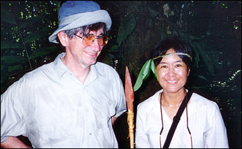
Rong Fu and her colleague Robert Dickinson visited the Amazon Rainforest during the 2nd LBA science conference. (Photograph courtesy Rong Fu, Georgia Institute of Technology.) | ||
 | |||
For Myneni, the Amazon project was sort of a maiden voyage for the leaf area product—a chance to really test the performance of a product to which he had devoted the past eight years of his life. But the choice to look for seasonal changes in Amazon leaf area wasn’t random. Myneni describes it as part of a continuing story, one with a series of surprises. The backdrop of the story is the Amazon rainfall cycle. Contrary to many people’s imagination, in most parts of the rainforest, it doesn’t actually rain all year long. Rong Fu describes how variable the rain in the Amazon Rainforest really is. “To the north of the equator, the rainy season is in the summer—June, July, August,” she says. “But the majority of the Amazon is south of the equator, and over these areas, the rainy season starts somewhere around October or November and ends somewhere between March and April, sometimes May.” There are east-west differences as well. In the west, the dry season may only last one to three months, while in the east and southeast, it may last five, or even seven months. The forest stays evergreen because many trees extend roots several meters into the soil, and they redistribute the water stored deep underground to places where the soil is dry. |
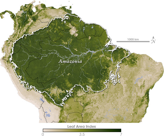
Leaf Area Index (LAI) values are high (dark green) throughout the majority of Amazonia. The grasslands south of Amazonia have sparse vegetation (light green) while the Andes to the west are almost completely barren (beige). LAI is defined as the proportion of the Earth’s surface covered by leaves. Values above 1 indicate multiple overlapping leaves, like the multi-tiered branches of a tree’s crown or multiple layers of vegetation. (NASA map by Robert Simmon, based on MODIS data.) | ||

Against this backdrop of regular seasonal droughts, scientists originally thought that plant and tree growth would slow down in the dry season. But in the mid-1990s, people began building research towers that reached as high as the forest canopy. When they measured the flow of carbon dioxide into and out of the forest from those towers, they got a surprise. “They reported seeing the ecosystem storing carbon during the dry season,” says Myneni. Either photosynthesis increased during the dry season, or processes that release carbon dioxide, like decay and respiration, decreased. Because the idea of better growth during the dry season seemed counterintuitive, the leading explanation for the dry-season carbon surplus was not increased photosynthesis. Instead, says Myneni, scientists speculated that hot, dry conditions slowed respiration, the physiological “flip-side” of photosynthesis. When plants, microorganisms, and fungi respire—break down sugars and starches for energy—they release carbon dioxide. If soil respiration slowed down in the heat, the forest would have a net gain of carbon. But over time, that explanation wasn’t able to account for all the evidence. In 2003, remote-sensing ecologist Rama Nemani of NASA’s Ames Research Center and seven other scientists, including Myneni, analyzed two decades of global satellite observations of clouds, sunlight, and vegetation. They found that while tropical cloudiness had declined, tropical vegetation had grown greener. These results suggested that tropical forest growth was limited not by dry-season water shortages, but by rainy season “sunlight shortages.” |
Rainfall in the Amazon varies in an annual cycle, with high rainfall north of the equator (aqua) in June, July, and August, and high rainfall south of the equator (red) in December, January, and February. (Graph by Robert Simmon, based on data from the TRMM Online Visualization and Analysis System.) | ||
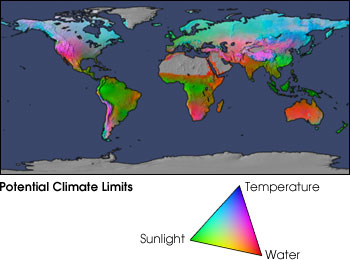
Increasingly, the idea that rainforests might actually be more productive in the dry season gained traction. The thing that finally motivated Myneni to investigate whether the Amazon had a detectable seasonal pattern of leaf area was a 2006 paper by fellow MODIS teammate Alfredo Huete. Huete used MODIS data to make maps of something remote-sensing scientists call greenness, a ratio of the relative amounts of red and near-infrared light that vegetation on the Earth’s surface reflects back to a satellite. Because plants absorb red (and other visible light) and reflect near-infrared light, a scale of vegetation greenness is a general indicator of the extent and density of vegetation within a satellite sensor’s field of view. With vegetation index maps, Huete showed that a majority of the Amazon was greener in the dry season than the wet. |
This map shows which of three key climate factors most limits plant growth in an area (red is water; green is sunlight; blue is temperature). The Amazon is strongly limited by the availability of sunlight: there is plenty of water and it’s always warm, but clouds often veil the Sun, slowing photosynthesis. (Image by Robert Simmon, NASA Earth Observatory, based on data provided by the University of Montana NTSG.) | ||
 |
|||
“A vegetation index is an intangible measurement of the greenness of the land surface,” explains Myneni. “It’s something that we measure with a sensor, but not a physical attribute of plants you can go out into the field and measure, like leaf area.” Huete had demonstrated that areas of increased greenness matched the carbon uptake and release cycles measured at research towers, but Myneni wanted to see if the increased greenness Huete had discovered had a forest-wide, physical dimension. Was leaf area changing with seasons? |
Satellite measurements collected over the Brazilian Amazon show seasonal changes in plant growth. The value of the enhanced vegetation index (a measurement of greenness) rises during the dry season, and falls during the wet season. (Map by Robert Simmon and Jesse Allen, based on data from the Oak Ridge National Laboratory DAAC.) | ||