The Earth Observatory has published its last Image of the Day on this website. Please join us on our new home at science.nasa.gov/earth/earth-observatory.
Monsoon Mystery | |||
Among the mysteries of the South American Monsoon, explains Fu, is how the first thunderstorms of the wet season get started. A monsoon is an atmospheric see-saw in which the large-scale circulation of the atmosphere reverses direction on a seasonal basis. Winds that previously blew in one direction now blow in the opposite direction. Areas that were dry for months now receive months of steady rain. The Amazon is in the realm of the trade winds, a belt of easterly winds that circles the globe a few degrees north and south of the equator. The winds bring moisture-laden air from the tropical Atlantic Ocean over the continent. Once that moisture-laden air is over the continent, northerly or southerly winds determine where in the Amazon the moisture will wind up. It is these winds that reverse during the monsoon. |
|||
 |
So what causes a monsoon to reverse directions? The key ingredient, Fu explains, is elevated heating, heating of the atmosphere at high altitudes. The heated air rises, and air from farther away flows in to replace it. It is the heat at high altitudes that drives the atmospheric flow to overturn on a large scale. The question for the Amazon is where that heating comes from. One way to get elevated heating is the presence of a large, high-altitude land surface. “For example, in the Asian monsoon, you have the Tibetan Plateau to provide elevated heating. When the seasons change, the Sun moves back to the Northern Hemisphere, back to the Plateau,” Fu explains. With an average elevation of several thousand meters above sea level, the Tibetan Plateau can heat the middle and upper layers of the troposphere—the atmospheric layer nearest Earth, where most weather happens. The Amazon, on the other hand, has no equivalent to the Tibetan Plateau. “In the Amazon Basin the only way to inject heat into higher altitudes of the atmosphere is convection, or thunderstorms,” says Fu. Repeated thunderstorms kick-start the large-scale overturning of the atmosphere that causes the north-south winds to switch directions. These facts left Fu with a riddle. In order for the wet phase of the monsoon to kick in over one part of the Amazon, the north-south winds must reverse direction and bring moisture into the basin. For the north-south winds to reverse direction, there must be heating at high levels of the atmosphere. To get heating high in the atmosphere in the Amazon, you need thunderstorms. “But how,” asks Fu, “can you have a thunderstorm before you have moisture being transported into the basin?” |
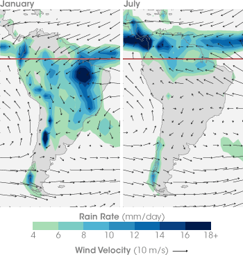
Between January and July the prevailing winds over the equatorial Amazon flip from blowing north to south in January to blowing south to north in July. The reversal of the winds brings moisture from the Atlantic and the Caribbean into different parts of the Amazon, shifting the rainy season back and forth between areas north of the equator and areas to the south. (Maps adapted from images provided by Wenhong Li.) | |
 |
|||
This question is where Fu’s path intersected with Myneni’s. Back in 2004, Fu and one of her students had published a paper, based on Amazon weather observations and models, in which they hypothesized that the Amazon forest itself provided the trigger. “We showed that evapotranspiration—the release of water vapor from vegetation leaves—increased near the end of the dry season.” The water vapor makes the air above the forest more buoyant (water vapor is lighter than dry air), allowing it to rise and initiate the season’s first thunderstorms. As water vapor in towering thunderstorm clouds condenses into rain, it releases heat into the atmosphere, beginning the process of overturning the atmosphere and reversing the monsoon. |
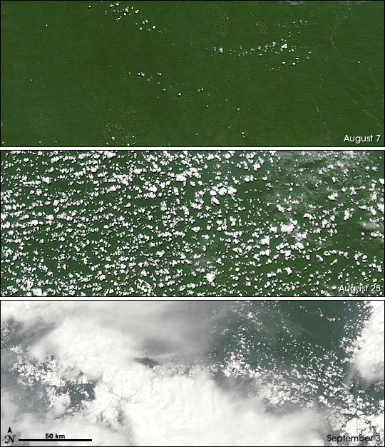
These satellite images show the progress from dry season to wet season. During the height of the dry season there are few clouds and little moisture above the forest canopy (above, top). As the trees grow leaves and photosynthesis increases, the humidity above the canopy increases, leading to popcorn-like clouds (middle). The energy released by the condensation of water vapor into water droplets drives convection and creates thunderstorms (lower). (NASA images from the MODIS Rapid Response System.) | ||
 |
“We concluded that a surge of evapotranspiration from the forest itself at the end of the dry season was needed to trigger the onset on the wet season. But we really didn’t know how evapotranspiration could increase,” says Fu. Then one day, she opened her e-mail and found a draft copy of the manuscript that Myneni was preparing on his discovery of the Amazon’s seasonal leaf area pattern. A mutual colleague, Robert Dickinson, who was helping to write and review the paper, had passed the draft along. “I was so excited,” Fu recalls. “I couldn’t believe it. When I talked to Ranga, I told him, ‘This is the missing piece; this is exactly what I didn’t know before.’ I was convinced that increased evaporation was necessary, but until I saw Ranga’s results, I did not know how we could get that increase.” The satellite data had provided one possible answer: more leaves. Since plants evaporate water from microscopic openings in their leaves, more leaves means more surfaces for evapotranspiration. Leaf and evapotranspiration increase throughout the dry season to maximize growth when sunlight is abundant. Evapotranspiration releases more and more water vapor throughout the dry season until eventually, the air above the forest is buoyant enough to trigger widespread, frequent thunderstorms. These thunderstorms flip the monsoon switch, causing more and more moisture to be drawn into the area and perpetuating the rainy season. In other words, the rainforest itself seems to make it rain. “I think it is just so interesting,” says Fu, “that there is this connection between the rain and the underlying ecosystem.” |
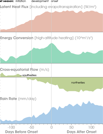
Roughly 90 days before the start of the wet season in the southern Amazon, latent heat flux (energy released during condensation of water vapor) increases as evapotranspiration (water released into the air from leaves) increases (first graph). Over the next 40 days, thunderstorms lift warm, moist air high into the atmosphere, where additional water vapor condenses, releasing even more heat energy (second graph). The heated air rises and overturns on an expanding scale, sucking in air from north of the equator and reversing the flow of the prevailing winds (third graph). The winds carry Atlantic Ocean moisture into the southern Amazon, resulting in steady seasonal rains (fourth graph). (Graphs adapted by Robert Simmon from Fu and Li 2004.) | |
 |
|||
The discovery of this connection has generated an explosion of questions for the project’s many collaborators, each with the potential of spawning another chapter in the ongoing story of the intimate connections between Earth’s tropical ecosystems and climate. Will ground-based measurements of leaf area, evapotranspiration, and monsoon onset match up in the same way that satellites suggest they do? What processes besides an increase in leaf area might cause evapotranspiration rates to increase in the dry season? Will satellite-based leaf area measurements of other tropical forests find seasonal patterns like the Amazon’s? How do El Niño events affect the seasonal leaf area and greenness patterns in the Amazon? Will deforestation and global warming disrupt the connection between the rainforest and the rain? As the stories unfold, who knows what other secrets tropical forests might reveal?
|
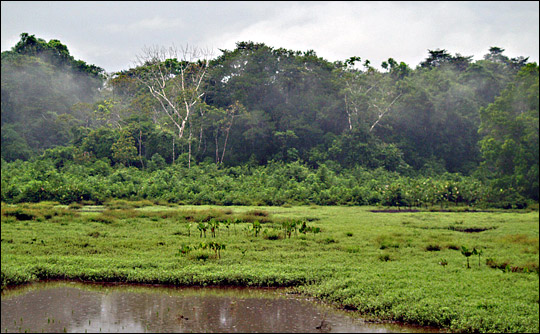
The vegetation of the Amazon rainforest has a surprisingly intimate connection with the atmosphere. Seasonal swings in the forest’s leaf area may not be just a response to seasonal rainfall cycles, but a cause of them as well. (Photograph ©2006 zrim.) | ||
