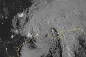
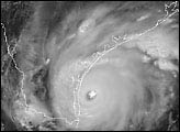
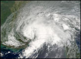
While category 5 Hurricane Patricia weakened rapidly after hitting the rugged terrain along Mexico’s Pacific coast, remnants of the storm combined with other weather systems over the Gulf of Mexico to produce heavy downpours and widespread flooding in Texas and Louisiana. At 3:20 am Central Time (0820 Universal Time) on October 26, 2015, the Visible Infrared Imaging Radiometer Suite (VIIRS) on the Suomi NPP satellite captured this image of Patricia’s remnants over the Gulf of Mexico and the southeastern United States.
The storm was captured by a special “day-night band,” which detects light in a range of wavelengths from green to near-infrared and uses filtering techniques to observe dim signals such as auroras, airglow, gas flares, city lights, fires, and reflected moonlight. In this case, cloud tops were lit by the nearly full Moon (full occurs on October 27). Some city lights in Texas, Arkansas, and Louisiana are visible through the clouds.
NASA Earth Observatory image by Jesse Allen, using VIIRS day-night band data from the Suomi National Polar-orbiting Partnership. Suomi NPP is the result of a partnership between NASA, the National Oceanic and Atmospheric Administration, and the Department of Defense. Caption by Adam Voiland.