

On Sunday August 27, 2006, Ernesto became the first storm of the Atlantic season to reach hurricane intensity. Ernesto did not maintain hurricane intensity for long, however, and was soon downgraded back to a tropical storm after grazing the southwestern tip of Hispaniola. Ernesto formed from an easterly wave—a low-pressure ripple in the atmosphere—that moved west across the Atlantic and into the Caribbean. After passing through the Windward Islands, the wave developed into the fifth tropical depression of the year on August 24.
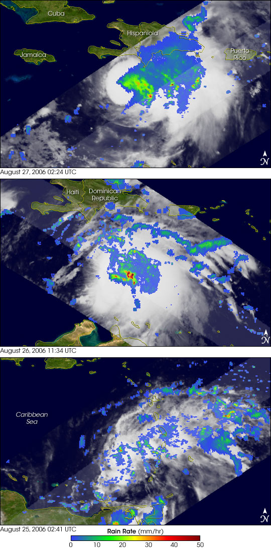
This series of images shows the development of the storm. The earliest image (bottom image in the trilogy) shows the storm in the southeastern Caribbean soon after it had formed. The image was taken 10:41 p.m. local time on August 24, 2006, (02:41 UTC on August 25) by the Tropical Rainfall Measuring Mission (TRMM) satellite. Rain rates in the center swath are from the TRMM Precipitation Radar, while those in the outer swath are from the TRMM Microwave Imager. The rain rates are overlaid on infrared data from the TRMM Visible Infrared Scanner. Scattered areas of light (blue) to moderate (green) rain and little evidence of classic hurricane organization reveal that the system was still in its early stages of development.
The storm developed into Tropical Storm Ernesto the next day, when the middle image in the series was taken. As the system tracked west-northwest, it encountered southwesterly winds at higher altitudes, a pattern that tends to shear off the tops of developing storms and to prevent them from gathering strength. These winds kept the storm from gaining much strength despite warm sea surface temperatures. Warm water is the engine that drives tropical storms. When this image was taken at 7:34 a.m. local time (11:34 UTC) on August 26, Ernesto was passing south of the Dominican Republic. At that time, intense areas of rain were present within the storm (red areas). However, Ernesto still did not have a visible eye, nor a particularly well-developed circulation, the spiraling band of clouds typically associated with tropical storms and hurricanes. At that time, the National Hurricane Center reported that Ernesto’s maximum sustained winds were 74 kilometers per hour (46 miles per hour).
Throughout the day, Ernesto continued to encounter high-altitude winds from the southwest that pushed the storm’s top eastward, creating the elongated oval shape seen in the top image. This image was obtained at 10:24 p.m. local time on August 26 (02:24 UTC, August 27), when Ernesto was approaching Haiti. Although the center of the storm did not fall within the center of the TRMM instruments’ fields of view, the rainfall pattern confirms that high-altitude winds were still confining the heaviest rains to the eastern side of the storm. At the time of this image, Ernesto’s sustained winds were up slightly to 92 km/hr (58 mph).
During the night of August 26, the shear across Ernesto finally eased off, and the storm responded by intensifying into a Category 1 hurricane. However, by this time, Ernesto was close to southwestern Haiti. Ernesto crossed the southwestern tip of Haiti on August 27, which caused it to weaken back to a tropical storm. Ernesto then continued northwest before making landfall in southeastern Cuba several hours later. As of August 29, Ernesto remained a somewhat disorganized tropical storm system. The storm was expected to reorganize as it left Cuba, but it was unclear if it would have enough time to develop back to hurricane strength before making a projected landfall in south Florida.
The TRMM satellite was placed into service in November 1997. From its low-earth orbit, TRMM provides valuable images and information on storm systems around the tropics using a combination of passive microwave and active radar sensors, including the first precipitation radar in space. TRMM is a joint mission between NASA and the Japanese space agency, JAXA.
Images produced by Hal Pierce (SSAI/NASA GSFC) and caption by Steve Lang (SSAI/NASA GSFC).