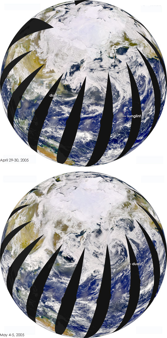


Springtime winds whip across the Gobi Desert of northern China and send dust flying east over the populated North China Plain. These regular dust storms are sometimes powerful enough to reach across the Pacific Ocean and dim skies over North America. In late April 2005, the Sea-viewing Wide Field-of-view Sensor (SeaWiFS) flying on the OrbView-2 satellite detected a large dust storm over China. Over the week that followed, SeaWiFS tracked the dust over the Pacific Ocean.
SeaWiFS collects imagery as it orbits the Earth from pole to pole. The above images were created by piecing together the strips from each orbit. Each strip measures approximately 1,500 kilometers across, and black wedges show where no data were collected. In the top image, acquired on April 29 and April 30, 2005, northern Japan is entirely obscured by a thick cloud of dust, and a tan streamer of dust stretches east over the Pacific. The lower image was taken on May 4 and May 5, 2005. By this time, the dust had reached about two-thirds of the way across the Pacific, well on its way to North America. Intermediate images are provided in the links above.
In both images, the sun’s reflection off the surface of the ocean forms a series of bright spots—sunglint— just north of the Equator.
SeaWiFS images courtesy the SeaWiFS Project, NASA/Goddard Space Flight Center, and ORBIMAGE. NOTE: All SeaWiFS images and data are for research and educational use only. All commercial use of SeaWiFS data must be coordinated with ORBIMAGE.