
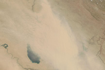
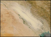
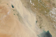
July 21, 2010, turned out to be a dusty day in parts of Iraq, including Baghdad. A long plume of dust extends down the length of the country in this photo-like image captured by the Moderate Resolution Imaging Spectroradiometer (MODIS) on NASA’s Terra satellite. The pale dust plume covers the brown-green web of plant-covered lands and wetlands that span the area between the Tigris and Euphrates Rivers. A steady west-blowing wind generated the dust storm.
The large image is the highest-resolution version of the image. The image is available in additional resolutions from the MODIS Rapid Response Team.
NASA image courtesy Jeff Schmaltz, MODIS Rapid Response Team at NASA GSFC. Caption by Holli Riebeek.
alert message


