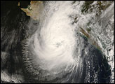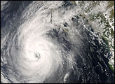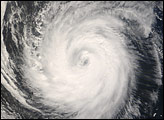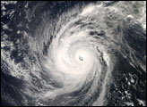

By the late morning of October 11, 2008, Hurricane Norbert’s eye hovered over Baja California. The Moderate Resolution Imaging Spectroradiometer (MODIS) on NASA’s Terra satellite took this picture at 11:20 a.m. local time (18:20 UTC). A report issued 20 minutes earlier by the U.S. National Hurricane Center stated that the eye of the storm was about 120 kilometers (75 miles) west-northwest of La Paz, and that the storm was moving toward the northeast at roughly 24 kilometers (15 miles) per hour. The report described the storm as a Category 2 hurricane with maximum sustained winds near 165 kilometers (105 miles) per hour.
In this image, the storm covers most of the southern half of Baja California, and in the northeast, the clouds extend over the Gulf of California and well into mainland Mexico. Skies are clear over northern Baja California but mostly cloudy over mainland Mexico.
According to the National Hurricane Center, Hurricane Norbert weakened as it passed over the mountains of northern Mexico the following day. On October 12, the storm’s winds had dropped to approximately 45 kilometers (30 miles) per hour. Norbert did not depart, however, without exacting a toll on the local population. Across southern Baja California, the storm removed roofs, dropped knee-high rain, and forced hundreds to flee, according to the Los Angeles Times. The Houston Chronicle reported that Norbert was expected to cause flooding in the Texas-Mexico border town of Presidio, which had already been saturated by previous storms.
NASA images created by Jeff Schmaltz, MODIS Rapid Response, NASA Goddard Space Flight Center. Caption by Michon Scott.
Forming in the Eastern Pacific, Hurricane Norbert became a severe hurricane. By October 11, 2008, it was situated over Baja California. By October 12, 2008, the storm had removed roofs and produced knee-high rain.


