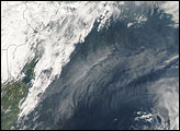
Thick haze extended off the U.S. East Coast on October 8, 2007. The Moderate Resolution Imaging Spectroradiometer (MODIS) on NASA’s Aqua satellite took this picture the same day. In this image, the translucent haze obscures the view of the Atlantic Ocean just off the coast. East of the Carolinas, the haze narrows into a thin band that continues eastward.
The haze clouding the skies in early October was likely smog, and it might have been partially caused by unseasonably warm temperatures. Much of the east coast experienced temperatures around 32 degrees Celsius (90 degrees Fahrenheit) at the time this haze formed. Ground -level ozone is a primary ingredient in smog, and such ozone forms in the presence of sunny skies and warm temperatures, along with pollutants released by industry and transportation.
Image courtesy Jeff Schmaltz, MODIS Rapid Response Team, NASA GSFC
alert message