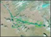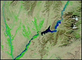

Rivers across Afghanistan were running high on April 2, 2007, when the Moderate Resolution Imaging Spectroradiometer (MODIS) on NASA’s Terra satellite captured the top image. The extensive flooding was triggered by weeks of late-winter and early-spring rain combined with melting snow. According to the United Nations Office for the Coordination of Humanitarian Affairs Integrated Regional Information Network (IRIN), 83 people had died in the flooding and thousands were in need of assistance as of April 1. The scale of the disaster led the Afghan government to declare a state of emergency in 13 of the country’s 34 provinces and to request assistance from the international community. In Herat, shown here, six people died and 200 families were affected in the floods.
The top image shows flooding in northwestern Afghanistan along the Harirud River, which flows through the city of Herat. The lower image was taken on March 6, 2007, a few days before the rains began, and it illustrates the extent of the river under normal conditions. The images were both made with infrared and visible light, a combination that highlights the presence of water on the ground. In this type of image, water is typically dark blue or black, but in this case, sediment is mixed in the water, giving it a lighter shade of blue. The desert landscape is tan-pink, brushed with green where plants are growing. Clouds are light blue and white, and snow is also light blue.
On April 2, the Harirud River is much wider than it was in early March. The cause of the flooding is partially evident in the large images: significantly less snow covers the mountains to the east (where the river has its headwaters) in the April image compared to the March 6 image. The decrease in snow cover is even more evident in the corresponding photo-like images (made entirely from visible light), which are available from the MODIS Rapid Response System on a daily basis.
NASA images courtesy the MODIS Rapid Response Team at NASA GSFC.
Rain and melting snow combined to trigger floods and landslides in southwestern Afghanistan in March and April 2007.

