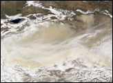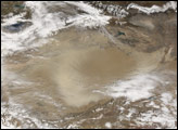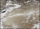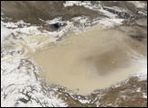

A combination of dust and clouds hovered over the Taklimakan Desert on March 13, 2006. The Moderate Resolution Imaging Spectroradiometer (MODIS) flying onboard the Terra satellite took this picture the same day. In this image, the dust storm appears as a pale beige swath sweeping over most of the desert. A portion of the desert, from the northeast toward the center, remains relatively clear of dust, showing the desert floor. White clouds fringe the desert’s perimeter.
One of Earth’s largest shifting-sand deserts, the Taklimakan Desert lies in the Tarim Basin, between the Tien Shan Mountains in the north and Kunlun Mountains in the south. The basin’s lowest point is roughly 150 meters below sea level, and salt collects there because the area has no drainage. Thanks to its aridity and abundant sand, this desert is a regular source of dust storms in Asia.
NASA image created by Jesse Allen, Earth Observatory, using data obtained courtesy of the MODIS Rapid Response team.
A series of dust storms moved westward over the Taklimakan Desert between February and April 2006.


