The Earth Observatory has published its last Image of the Day on this website. Please join us on our new home at science.nasa.gov/earth/earth-observatory.

About 600 million years ago, during the Ediacaran Period, Earth was a vastly different place. The land, having recently shed a global blanket of slushy ice, was mostly barren and lifeless. However, an array of bizarre, soft-bodied creatures thrived in shallow seas, including worm-like organisms with crescent heads, spiral-shaped mounds with unusual trilateral symmetry, and fern-like fronds that grew several feet tall.
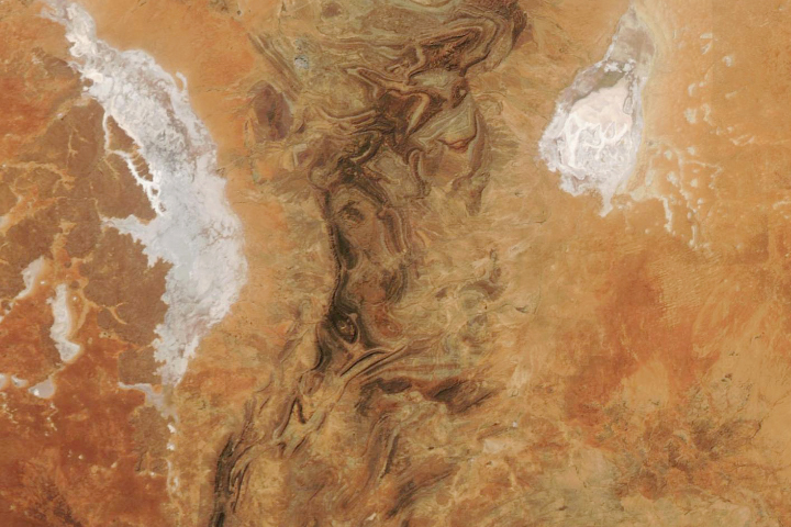
Creatures like these may have been obliterated when an asteroid, thought to be roughly 200-400 meters (700-1300 feet) across, blazed through the sky and smashed into land or shallow waters around what is now the Davenport Range of northern Australia. While much of the original impact crater has eroded, telltale signs of the collision remain imprinted on the folded sedimentary and volcanic rock layers.
On February 3, 2025, the Operational Land Imager (OLI) on Landsat 8 captured this view of the impact site, an area called the Amelia Creek impact structure. The collision gouged a canoe-shaped trough about 1 kilometer wide and 5 kilometers long. An analysis of satellite observations shows deformation in the regional rock strata extends about 10 kilometers north and south of the impact crater, with minimal deformation to the east and west.
The long, narrow shape of the crater and the pattern of regional deformation are signs that the asteroid struck at an extremely oblique (shallow) angle. A steeper-angle asteroid impact—such as the one that doomed the dinosaurs—would have left a deeper, more symmetrical crater and created an elevated feature in the center of the crater known as a central uplift.
Other telltale clues of an impact event at Amelia Creek are buried in nearby quartzite rock strata. Starting in the 1980s, geologists discovered fan-shaped fractures, later identified as shatter cones—rare geologic features that only form when impact events send shock waves barreling through rock. All of the area’s shatter cones are distributed in a crescent-like pattern mainly to the south of the crater, another sign that the asteroid struck at a shallow angle.The amount of damage caused by the impact is unclear, but asteroids that hit Earth at shallow angles are thought to cause less damage than those that strike at steep angles. The shallow angle means the rocky body passes through Earth’s atmosphere for a longer distance, burning off more mass and often breaking into smaller pieces before impact.
While the most severe damage was probably localized near the site of the collision, geologists have assembled evidence suggesting that two other larger impacts during the Ediacaran may have had much greater and even global effects, possibly contributing to the extinction of an enigmatic class of creatures called acritarchs and helping cause global changes in ocean chemistry and climate.NASA Earth Observatory image by Wanmei Liang, using Landsat data from the U.S. Geological Survey and using topographic data from the Shuttle Radar Topography Mission (SRTM). Story by Adam Voiland.