Editor’s note: This story has been revised to correct the description of the sediment plume’s source.
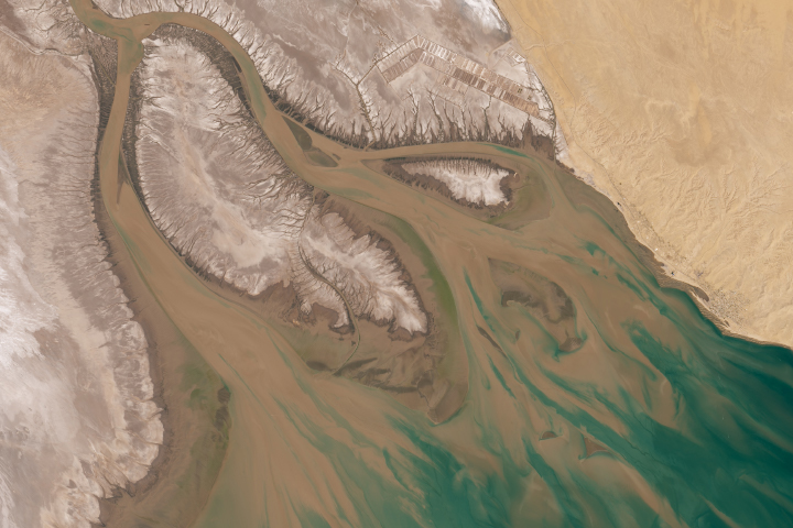
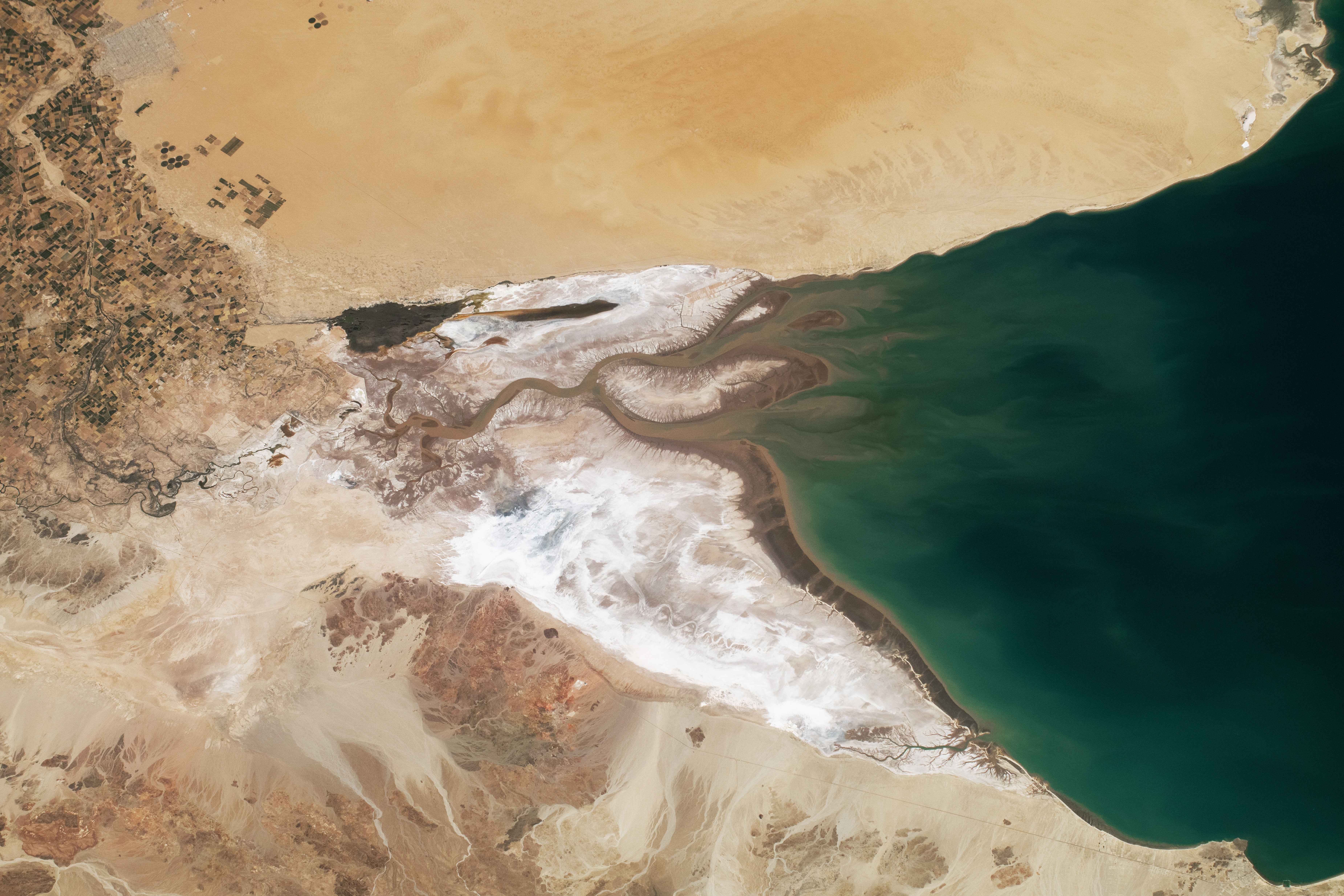
Astronauts aboard the International Space Station took this photograph of the Colorado River Delta while orbiting over the coast of Baja California, Mexico. This delta is where the Colorado River, one of the longest rivers in North America, once flowed into the Gulf of California, more than 2,330 kilometers (1,450 miles) from its source in the Rocky Mountains. Part of the delta lies within the Alto Golfo de California y Delta del Río Colorado Reserve. Other parts of the floodplain make up the intensively farmed Mexicali Valley (top left), which extends to the north and connects with the Imperial Valley in California (out of frame).
For millions of years, the Colorado River deposited sediments in a rift valley created by tectonic processes associated with the Salton Trough. Over geologic time, these sediments formed an expansive delta and nutrient-rich wetlands. The river’s discharge was drastically reduced as its flow was diverted upstream for urban use and agricultural irrigation. The construction of dams in the United States, such as the Parker Dam and Hoover Dam, significantly reduced water flow to areas downstream.
The present delta is made of a series of islands, islets, and channels that have been shaped by water flow and sedimentation to create a landscape of lowlands and marshes. Dark, narrow channels and tributaries, such as the Hardy, curve through the salt-encrusted landscape. These salty mineral deposits result from high evaporation rates, and they highlight the Colorado River’s dramatic reduction in water flow in this area compared to its source regions. One of the area’s most prominent salt flats is visible on the western side of the delta.
Although water from the Colorado River no longer reaches the Gulf of California, strong tidal currents can redistribute sediment, likely leading to the light brown plumes visible in this image. The interaction between reduced freshwater and rising salinity levels has transformed what was once a dynamic estuarine system into an arid environment.
Adjacent to the delta lies the Desierto de Altar (Altar Desert), composed of extensive sand dunes with minimal vegetation. Toward the bottom of the frame, the Sierra las Pintas are characterized by red- and black-hued rocks. Nestled between the desert and agriculture, the city of San Luis Río Colorado appears light gray.
Astronaut photograph ISS071-E-138692 was acquired on May 29, 2024, with a Nikon Z9 digital camera using a focal length of 140 millimeters. It is provided by the ISS Crew Earth Observations Facility and the Earth Science and Remote Sensing Unit, Johnson Space Center. The image was taken by a member of the Expedition 71 crew. The image has been cropped and enhanced to improve contrast, and lens artifacts have been removed. The International Space Station Program supports the laboratory as part of the ISS National Lab to help astronauts take pictures of Earth that will be of the greatest value to scientists and the public, and to make those images freely available on the Internet. Additional images taken by astronauts and cosmonauts can be viewed at the NASA/JSC Gateway to Astronaut Photography of Earth. Caption by Wilfredo García López, Amentum JETS II Contract at NASA-JSC.
alert message