The Earth Observatory has published its last Image of the Day on this website. Please join us on our new home at science.nasa.gov/earth/earth-observatory.

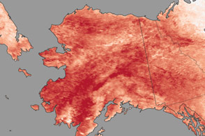
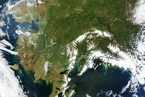
A spell of unseasonably warm weather in winter 2024–2025 has meant less snow for parts of the normally frozen state of Alaska.
These images show the Bristol Bay Borough in southern Alaska. Notice the vast area of bare ground in the image on January 26, 2025 (right), compared to the image captured around the same time one year prior (left). They were acquired by the MODIS (Moderate Resolution Imaging Spectroradiometer) on NASA’s Terra and Aqua satellites.
Since December 2024, temperatures across the state were 5–10 degrees Fahrenheit (3–6 degrees Celsius) above normal, according to NOAA, with isolated areas experiencing even greater anomalies. The warm temperatures caused existing snow and ice to melt and new precipitation to fall as rain. In early December, the National Weather Service (NWS) in Anchorage (northeast of this image) issued a warning of potential flooding and ice jams due to melting ice, according to news reports.
Warm conditions and melting continued into January 2025, by which time little snow clung to the ground of the lower elevations near King Salmon, Alaska. The average snow depth (between 1998 and 2025) at the NWS office in Anchorage on January 29 is about 13 inches (33 centimeters), but this year, the station measured no snow on the ground on that date.
A blast of sub-zero temperatures hit southern Alaska on January 27 and lingered until January 30. Warmer-than-average temperatures were expected to return in early February, according to local forecasts.
NASA Earth Observatory image by Wanmei Liang, using MODIS data from NASA EOSDIS LANCE and GIBS/Worldview. Story by Emily Cassidy.