The Earth Observatory has published its last Image of the Day on this website. Please join us on our new home at science.nasa.gov/earth/earth-observatory.


After hitting Florida, Hurricane Helene delivered torrential rains to communities in western North Carolina on September 27, 2024. The deluge followed two days of heavy rains that had already saturated soils and pushed the region’s rivers to unusual heights. The combined rainfall from these two events, amplified by the area’s rugged terrain, produced deadly and destructive flash floods.
Swollen rivers submerged entire communities, swamped farmland, unmoored buildings from their foundations, and swept away power and water infrastructure. While clouds have blocked most optical imagery of the flooding collected by NASA satellites so far, sensors on the NASA-USGS Landsat 8 and 9 and the European Space Agency’s Sentinel-2 satellites captured occasional glimpses of communities affected by the flooding in the days after Helene passed.
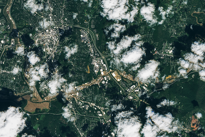
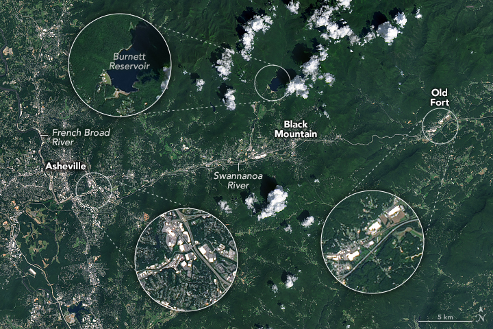
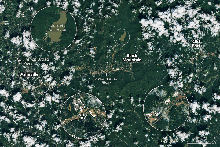
The MSI (MultiSpectral Instrument) on Sentinel-2 captured images of flooding on the French Broad and Swannanoa rivers near Asheville and Old Fort (above right), and near Swannanoa (below) on October 2, 2024. The other image (above left), captured by the OLI (Operational Land Imager) on Landsat 8, shows the same area on August 30, 2024, when rivers were at more normal levels. The pair of images below is a detailed view of the town of Swannanoa before and after flooding.

Saturated soils contributed to widespread runoff. This led to erosion and an accumulation of suspended sediment in floodwaters that turned waterways brown. In many areas, floodwaters appear to have receded when the satellite captured the image, but brown slicks of mud and debris remained visible.
Many of the towns in these images suffered extensive damage. Water submerged large parts of Asheville, including the Rivers Arts District and Biltmore Village, according to the Asheville Citizen-Times. A day before this image was acquired, ABC9 reported that Black Mountain lacked power, water, sewer, and passable roads. In a story about Swannanoa, The Washington Post described mangled homes, mud-choked roads, and cars in tree limbs.
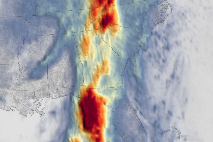
In conditions that some meteorologists have called a 1,000-year flood, the combination of Helene and the predecessor rain event pushed three-day rain totals to extraordinary levels. One weather station in Yancey County recorded as much as 31 inches (78 centimeters) of rain between September 25-27, according to data collected by the National Weather Service’s Cooperative Observer Program. Other stations in the county saw more than 24 inches, and parts of Henderson and Allegheny County received more than 17 inches. The weather station at Asheville Regional Airport had already recorded nearly 14 inches when it stopped working on the morning of September 27.

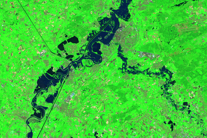
With the region’s mountains already saturated, large volumes of runoff poured into waterways and helped push several rivers to record heights. On September 27, the gauge on the French Broad River in Asheville measured water levels at 24.7 feet, which is more than a foot higher than the previous record. The nearby Swannanoa River at Biltmore rose to 26.1 feet, breaking the previous record by more than 6 feet. The false-color image of flooding in farmland near Asheville Regional Airport, shown above, was acquired by the Operational Land Imager (OLI) on Landsat 8. In this image, river water appears dark blue.
A week after Helene hit, the region remained in a state of emergency. On October 4, more than 220,000 customers in North Carolina were without power, according to PowerOutage.us. That included 50 percent of customers in Buncombe County, 58 percent in Henderson County, 79 percent in Mitchell County, and 52 percent in Yancey County.
Access to clean water was a problem in several communities. In Asheville, the storm severely damaged key water mains and transmission lines to the North Fork Water Treatment Plant, as well as the roads required to service them. There were also reports of high turbidity at Burnett Reservoir, which supplies water to the North Fork Water Treatment Plant. In an update on October 4, Asheville authorities said it was not possible to estimate a precise timeline for restoring service to the city’s entire water system but said it could potentially take weeks.
NASA’s Disasters Response Coordination System has been activated to support agencies responding to the storm, including the Federal Emergency Management Agency (FEMA). The team will be posting maps and data products on its open-access mapping portal as new information becomes available about flooding, power outages, precipitation totals, and other topics.
Editor’s Note: An earlier version of this story misidentified the town of Old Fort as Black Mountain. The story and image were corrected on October 28, 2024.
NASA Earth Observatory images by Michala Garrison and Lauren Dauphin, using Landsat data from the U.S. Geological Survey and modified Copernicus Sentinel data (2024) processed by the European Space Agency. Story by Adam Voiland.