Glaciers seem like stoic monuments, resting quietly among alpine peaks. From afar, they appear static and permanent, but for scientists engaging in meticulous fieldwork, the up-close view of the ice offers a vastly different perspective.
On a hot day in August 2024, glaciologist Mauri Pelto and his team worked their way up the Easton Glacier, on the flanks of Mount Baker in Washington. The glacier’s surface was alive with flowing water. A network of small channels fanned out across the ice, sparkling with fresh meltwater. Gurgling rivulets gathered into larger streams and carved channels into the ice. Some of the meltwater tumbled into a hole—called a moulin—making a deep, echoing sound as it disappeared and made its way down to the base of the glacier. Near the glacier’s terminus, a muddy river sent recently melted ice surging downstream to the Baker River and toward the Pacific Ocean.
Mauri is the founder of the North Cascade Glacier Climate Project. He works with his daughter, Jill Pelto, who is both a climate scientist and artist. Each summer, the father-daughter team invites a rotating crew of scientists, journalists, and artists on their field expedition. The 2024 field season marked the 41st year of detailed measurements on 16 different glaciers in Washington’s North Cascade mountains, which stretch 115 miles (185 kilometers) from Snoqualmie Pass to the Canadian border. The project’s mission is to learn how the glaciers across the entire mountain range are responding to climate change.
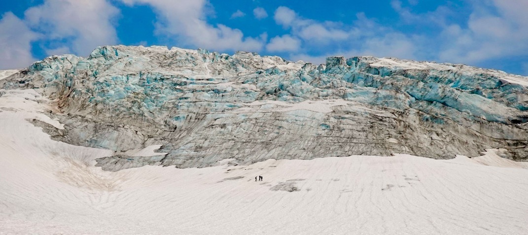
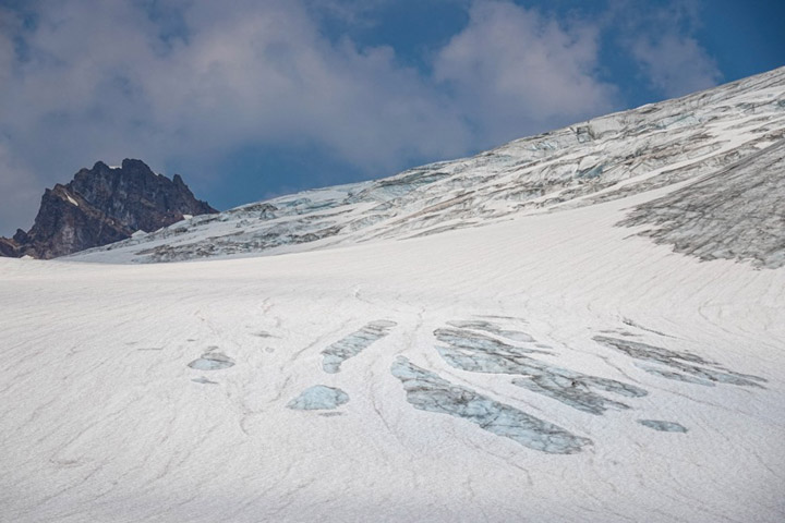
In the depths of winter, a blanket of snow accumulates on top of glaciers. When warm weather arrives, the covering of snow begins to melt off, first at lower elevations and then reaching higher up the slope. As last winter’s snow melts away, it reveals old, bare ice that is darkened with sediment and jagged with crevasses. Once this ice is exposed to the summer sunshine, the glacier begins to melt in earnest. Patches of bare ice are visible in this photo of Easton Glacier (below), taken in August 2024.
The team hiked up the water-saturated ice under hazy skies, laced with smoke from nearby wildfires. Mauri paused to take stock of the conditions. “We’re at about 6,300 feet (1,900 meters) of elevation,” he said. “Usually this slope has 2 to 5 feet (60 to 150 centimeters) of snow on it in early August, and obviously it has no snow this year. Even in bad years, it used to have some snow.”
Jill described how there used to only be a short window in late summer when the glacial ice had lost its protective snow cover. But now, warm summers leave the ice exposed for much longer, allowing more time for the ice to melt.
Based on decades of working on these glaciers, Mauri estimated the toll of just a single day of melting: “Today we’re going to have around 8 centimeters (3 inches) of melt here. Just in one day,” he said. “That’s 8 centimeters of glacier thinning instead of just snowmelt from the previous winter.”
The overall balance of winter snow compared to summer melt is called the glacier’s mass balance. “It’s like your checkbook,” Mauri explained. “You have your income, that’s the snowfall. Then you have your expenses, and that’s the snow melt.” If a glacier loses more water in the summer than it gains in the winter, it loses mass. By the end of the summer, a glacier needs to have 50 to 60 percent of its surface still covered by snow to stay in balance. When glaciers lose mass year upon year, they begin to retreat, thin, and visibly shrink.
The Peltos calculate mass balance by measuring the position of the snow line and the depth of the snow. They measure the snow depth by driving a metal probe through the snow at regular intervals across the glacier. Satellite images show the position of the snow line, but they can’t easily determine how deep that snow is—that’s where fieldwork comes in. Over two days, the team made 200 snow depth measurements on the Easton Glacier, and they did similar work on 8 other glaciers in the North Cascades this summer.
Mass balance measurements can be an early warning of glacier dynamics. “It’s the most sensitive climate indicator for glaciers because it gives you an annual signal,” Mauri said. By the time changes in the glacier’s size or position become apparent, the glacier has likely gone through several years with a negative mass balance.
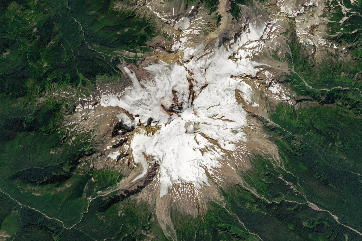
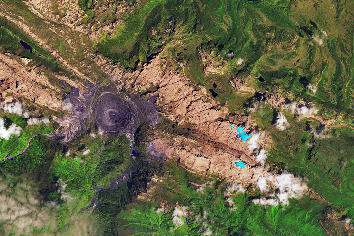
After collecting field measurements in early August, Mauri watches the rest of the melt season with Landsat imagery. For example, the image above shows Mount Baker and Easton Glacier on August 17, 2024, acquired with the OLI-2 (Operational Land Imager-2) on Landsat 9. As the snow line retreats uphill, the combination of satellite data and field measurements allows him to calculate the volume of water that has melted away since the field observations.
The high-resolution images from Landsat 8 and 9 have made Mauri’s job easier. The images “have such good resolution that I can use them to map the migration of the snow line, which is the dividing line between where a glacier is gaining mass and where it’s losing mass,” he said. “And that’s such a key tracker of how a glacier is doing.”
These measurements show a dramatic loss of ice in recent years. Mauri recalls that during the first 30 years he worked on North Cascades glaciers, they were losing around 1.5 feet (50 centimeters) of ice thickness each year. Now they’re losing over 4 feet (125 centimeters) per year. At the same time, the ice has been retreating uphill more than 100 feet (30 meters) every year.
“It’s not just here, it’s everywhere else,” he said with a sweep of his hand across the horizon. “With alpine glaciers around the world, we really see the mass loss is accelerating.”
“Temperatures are just too warm,” he said. Even a normal amount of snowfall is no match for the warming this region has been experiencing throughout the spring, summer, and fall. The winter’s store of snow is “just so easily erased.”
If the Easton Glacier had a bank account, it would be reaching deep into its savings every day of the late summer.
After completing two hard days of fieldwork, the team watched the last threads of alpenglow on the glacier and reflected on their findings. The tone at camp shifted from scientific to personal.
Jill has been working on these glaciers since she was just 16 years old. “It hits me really hard,” she said.
Mauri nodded. “Winter can’t come soon enough. I wish I could wrap the glacier in a blanket and protect it.”
NASA Earth Observatory image by Wanmei Liang, using Landsat data from the U.S. Geological Survey. Story and photographs by Karin Kirk, NASA’s Jet Propulsion Laboratory.
Scientists use satellites in orbit and boots on the ice to monitor glacial changes on the flanks of Mount Baker and elsewhere in Washington state.
Image of the Day for September 19, 2024
View more Images of the Day:

alert message