Russia’s Kamchatka Peninsula is home to one of the most concentrated groups of active volcanoes in the world, so it is no surprise that volcanologists observe new minor explosions, fumaroles, and hot avalanches at one of the peninsula’s 29 active volcanoes virtually every day.
Far less common is for the Kamchatka Volcanic Eruption Response Team (KVERT) to report on two major explosive eruptions that blast volcanic material clear into the stratosphere within the same week. That is what happened in mid-April 2023, when both Bezymianny and Shiveluch (sometimes spelled Sheveluch) roared into action.
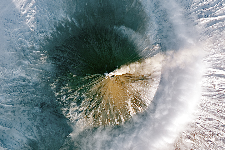
Shiveluch was the far more powerful of the two eruptions. Very early on April 11, a towering plume of ash and gas billowed upward as explosions rocked Shiveluch’s summit crater. Initial estimates indicated that the plume soared to at least 10 kilometers (6 miles) above sea level, while others suggested parts of it may have reached altitudes up to 20 kilometers. Ash, which is comprised of tiny shards of volcanic glass, posed a threat to aviation, prompting KVERT to elevate its aviation warning to code red.
Later in the day, reports of thick, gray ash deposits smothering villages began to circulate in the news media. As much as 8.5 centimeters (3.5 inches) of ash—more than has fallen in several decades—fell in some areas, according to Reuters.
“[This] looks like the largest Shiveluch eruption of the satellite era,” said Michigan Technological University volcanologist Simon Carn. The satellite records of volcanic activity Carn works with begin in 1978.
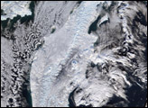
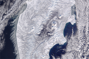
The pair of satellite images at the top of the page show the area around Shiveluch on April 11, 2023. Thin clouds obscure the view, making it difficult to distinguish between clouds and snow in the natural-color image (above-left), but some details are easier to distinguish in the false-color image (above-right). With this combination of blue and shortwave infrared observations (bands 3-6-7) snow appears orange and ice appears bright red. Ice clouds are pink and water clouds are white. Much of the ash (blue and gray) was likely still drifting high in the atmosphere when the image was acquired, though some of it may have started to accumulate on snowy land surfaces. The small dark area near Shiveluch’s summit is the plume’s shadow.
The eruption was powerful enough to send volcanic material soaring into the stratosphere. Scientists watch closely when volcanic materials—especially sulfates—reach this relatively dry layer of the atmosphere because particles linger much longer and travel much farther than if they remain in the lower, wetter troposphere. If enough volcanic material reaches the stratosphere, it can start to exert a cooling influence on global temperatures.
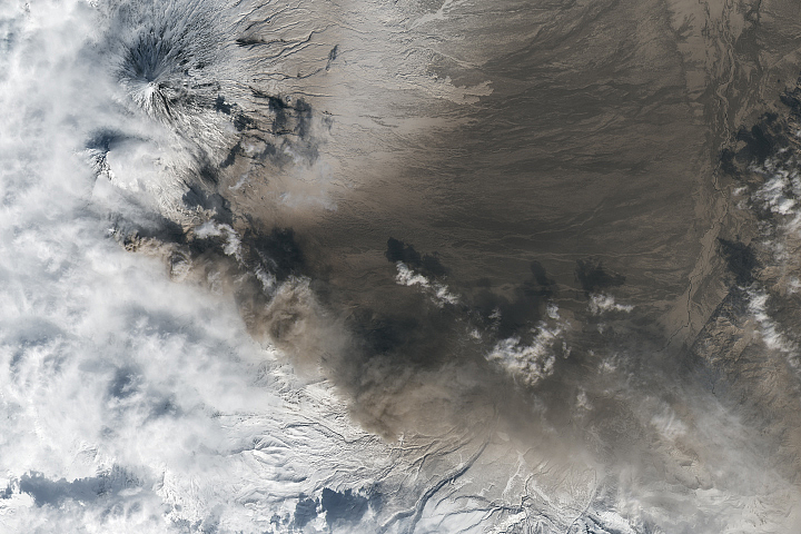
A few days earlier, it was Bezymianny’s turn. The volcano, about 100 kilometers (60 miles) southwest of Shiveluch, has been puffing with small-scale explosions for weeks, but strong explosions sent volcanic materials soaring up to 10-12 kilometers early in the day on April 7, also prompting KVERT to raise its aviation warning to code red. As this high-altitude ash streamed east, the intensity of the eruption slowed over the course of the day. By the end of the day, KVERT declared the period of strong eruptions over.
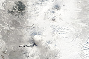
The Operational Land Imager (OLI) on Landsat 8 acquired imagery of the eruption at 10:15 a.m. local time (00:15 UTC) on April 7. The image shows ash blanketing a snowy landscape to the east of Bezymianny. After a period of quiet that geologists think had spanned roughly 1000 years, Bezymianny erupted violently in 1957. It has been frequently active ever since, according to data published by the
“It’s interesting that these two eruptions occurred within a few days of each other, but this is almost certainly just coincidence as both volcanoes are persistently active,” said Carn.
NASA Earth Observatory images by Lauren Dauphin, using MODIS data from NASA EOSDIS LANCE and GIBS/Worldview and Landsat data from the U.S. Geological Survey. Story by Adam Voiland.