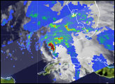

NASA’s Tropical Rainfall Measurement Mission (TRMM) satellite captured this image of the rainfall structure inside Tropical Storm Arlene, the first named tropical cyclone of the 2005 Atlantic hurricane season, on the morning of June 10, 2005. The storm formed on June 8 as a tropical depression and became a tropical storm on June 9.
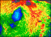
The satellite shows a large cluster of thunderstorms on the northeast side of the storm’s center, where a dark red circle indicates heavy rain. Within this cluster, clouds extend up to 17 kilometers (56,000 feet), pushed high by the intense energy of the storm. When such clouds are located at the center of the storm, the energy they release feeds the storm and allows it to intensify. In this case, strong winds are blowing these energetic clouds away from the storm’s center so that heavy rain does not coincide with the wind circulation. Arlene's disorganized wind circulation means that the distinctive swirl of clouds that characterizes most tropical cyclones is not immediately obvious in this image.
TRMM is a joint mission between NASA and the Japanese space agency JAXA.
Image produced by Hal Pierce (SSAI/NASA GSFC) and caption by Jeffrey Halverson (NASA GSFC).
Tropical Storm Arlene became the first tropical cyclone of the 2005 Atlantic hurricane season on June 8, 2005. The storm grew into a tropical storm on June 9 as it moved through the Gulf of Mexico.

