
As soon as the snow began melting in May 2021, fires broke out in the Republic of Sakha (Yakutia) in eastern Russia. Over the spring and summer, blazes have proliferated and intensified. By August, fires had consumed large swaths of the region’s larch forests. Plumes of smoke blanketed skies, turning day into night, closing airports, and prompting talk of an “airpocalypse” in the city of Yakutsk.
The Moderate Resolution Imaging Spectroradiometer (MODIS) on NASA’s Aqua satellite acquired this natural-color image of large clouds of smoke spreading over Sakha on August 8, 2021. Plumes of this size and opacity have been common for weeks, leading to poor air quality for many of the 280,000 people who live in the nearby city of Yakutsk. A few days before the image was captured, Russia's aerial fire protection service reported 178 active wildfires in Sakha. More than 2,600 people and 380 pieces of equipment were fighting fires at that time.
In an area as large and remote as Sakha, satellites offer one of the best options for monitoring wildfire activity and tracking the severity of seasonal fire outbreaks. According to Mark Parrington, a scientist with the European Centre for Medium-Range Weather Forecasts, the 2021 Sakha wildfires have set a record for estimated carbon emissions for the period from June 1 to August 1. Parrington monitors fires for the Copernicus Atmosphere Monitoring Service (CAMS) using a satellite-based data record that began in 2003.
Counted together with major fires in North America, Africa, and Europe, the Sakha fires helped push global wildfires emissions to record levels in July 2021, according to CAMS data. CAMS estimates near-real-time wildfire emissions from its Global Fire Assimilation System (GFAS), which aggregates observations of fires acquired by NASA’s Aqua and Terra satellites.
“Based on current official burned area reports, Sakha is on track to have an extreme year of fire, but it won’t surpass previous extreme years if the fires are extinguished by the end of August,” said earth scientist Jessica McCarty of Miami University (Ohio). “If large fire events continue into September and October, we could see burned area totals surpassing 2020.”
Vast areas of Yakutia have burned in the past 20 years, according to one recent analysis. About half of the fires in the region are caused by lightning. One team of researchers estimated that people start about one-third of Sakha’s fires with discarded cigarettes, sparks from vehicles, negligence with campfires, and arson. Other common causes include power line failures, crop fires, and logging.

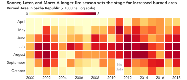
An analysis of past fires in Sakha indicate that the total number of fires has declined in recent decades even as the area burned has increased. The trend is likely driven by changes in where people live and in how forests have been managed. Many people in the region moved from small settlements in the countryside into larger towns and cities, and fires are often allowed to burn in rural areas. Closer to cities, fires are typically extinguished.
Climate change is likely playing a role in how fire seasons in Sakha are changing. “There have always been large fires in Siberia. It is a landscape evolved to burn,” said McCarty. “What is different because of climate change is that fires are burning larger areas, affecting places farther to the north, and consuming fuels that would have been more fire resistant in the past.”
NASA Earth Observatory image by Joshua Stevens, using MODIS data from NASA EOSDIS LANCE and GIBS/Worldview, and data from Kirillina, K., et al. (2020). Story by Adam Voiland.