The Earth Observatory has published its last Image of the Day on this website. Please join us on our new home at science.nasa.gov/earth/earth-observatory.


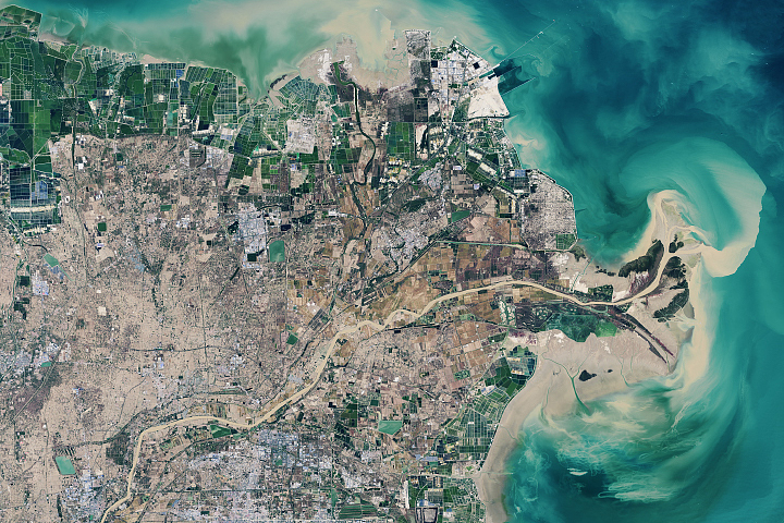
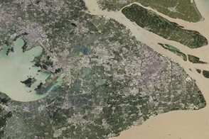
Few rivers carry as much sediment as the Huang He (Yellow River) in China. The name itself comes from the muddy color of the water—a consequence of the river’s upper and middle reaches flowing through a region in northwestern China with unusually fine and powdery soil called loess.
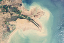
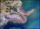
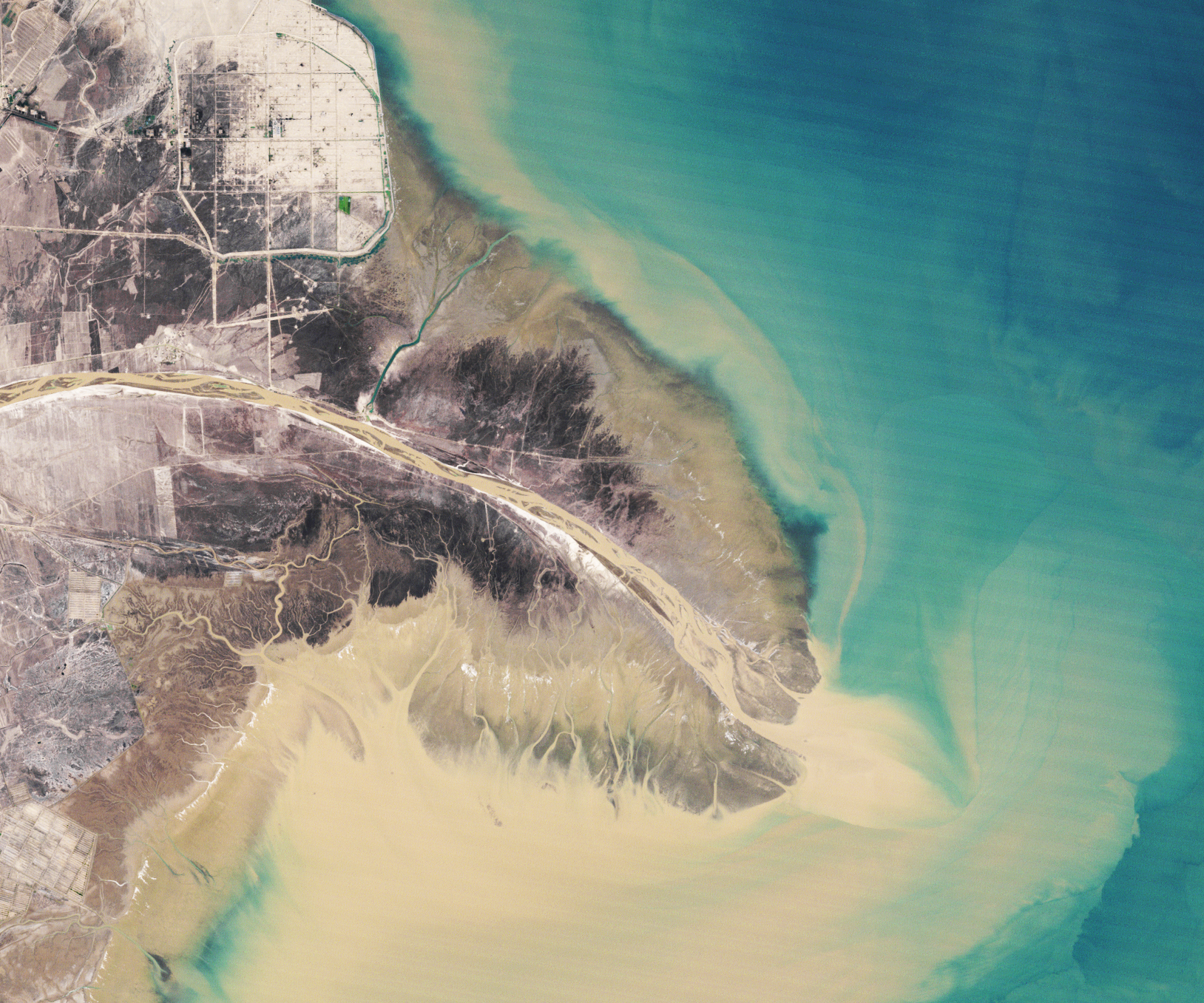
All of the silt in the water supercharges the river’s ability to build new land at its delta, the area where it dumps its sediment into the shallows of the Bohai Sea. In this pair of Landsat images, note how much the easternmost lobe of the delta changed shape between 1989 and 2020 as the river delivered new sediment to some parts of the delta and erosion ate away at older coastlines. (Read our Yellow River Delta World of Change story to see more imagery of the delta.)
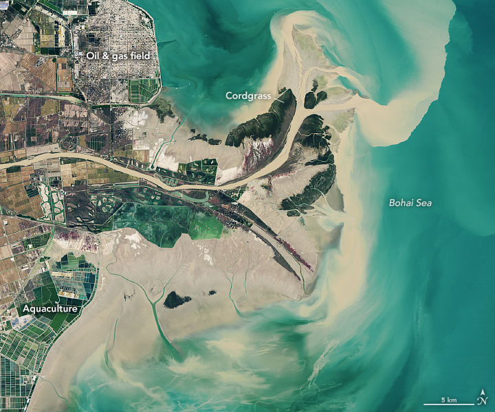
One of the most noticeable changes resulted from a diversion project that Chinese engineers completed in 1996, blocking the main channel and steering water and sediment to the northeast. The project’s purpose was to create new land in an area with offshore oil and gas to make the resource easier to extract. Before completion, new land formed along a rounded peninsula oriented to the southeast; afterward, the abandoned channel narrowed and new land began forming to the northeast, even as erosion ate away at parts of the older peninsula.
Other features in this area have seen equally dramatic changes. Aquaculture and salt evaporation ponds—the green and blue rectangular features along the coasts—have proliferated. So has oil drilling infrastructure (small rectangular features) due to the rapid expansion of Shengli Oil Field, now China’s largest. Several smooth-edged sea walls and dykes have been built along the coast in an attempt to protect the new oil, aquaculture, and other infrastructure from encroaching tides.
On the youngest land, different types of vegetation—notably the cordgrass Spartina alterniflora—have spread widely, creating dense new pockets of green in the 2020 image. The invasive cordgrass first reached the Yellow River Delta in the late-1980s, and began to spread rapidly in the intertidal zone in the early 2000s. While the grass does stabilize the shoreline, it has crowded out a local reed species (Phragmites australis) and an annual plant (Suaeda salsa), significantly reducing how much carbon the delta ecosystem stores and increasing methane emissions. By replacing S. salsa, the cordgrass has also made the area less habitable for certain rare birds, including red-crowned cranes and black-billed gulls.
Like many deltas around the world, the Yellow River Delta faces growing pressure from the sea for several reasons. By 2020, many of the coastlines shown here had retreated inland by a few kilometers as the sea overwhelmed tidal mud flats and marshes. This is partly because the delta itself is sinking. Freshly deposited mud naturally settles and compresses over time.
Human activity—particularly the pumping of groundwater for aquaculture—has accelerated the process. Though less influential, the process of pumping oil from below the surface and bringing in heavy equipment may have contributed to the subsidence as well. For much of the area shown in this image, scientists have reported subsidence rates of 20 millimeters (0.8 inches) per year. Layered onto both phenomena is global warming and sea level rise. Warming ocean water and the addition of fresh water to the oceans from melting ice sheets and glaciers is thought to contribute about 3 millimeters of sea level rise per year in this area.
Finally, the Yellow River now carries only a tenth of the sediment that it did during the 1960s and about half of what it did in the 1980s. Several dams, erosion-control projects, and reforestation projects in upstream farming areas now trap much of the water and sediment that would otherwise reach the delta naturally.
Efforts to flush sediment from clogged reservoirs and to scour sediment from the river bed led to a spurt of accelerated land formation in the delta between 2002-2014. However, the volume of sediment reaching the delta began dwindling in 2014 as coarser sediments coated and “armored” the river channel in key areas, preventing additional scouring. Since 2014, the delta has once again begun to lose more land each year than it gains.
NASA Earth Observatory images by Lauren Dauphin, using Landsat data from the U.S. Geological Survey. Story by Adam Voiland.