
For thousands of years, Cairo has been the cultural, political, and financial heart of Egypt. But even for such an indispensable and dynamic city, the pace of change during the past few decades has been remarkable.
Between 1984 and 2020, the population of greater Cairo grew from roughly 12 million people to more than 20 million, making it the largest city in Africa and the 15th largest in the world. Just seventy years ago, it had only 2 million people.
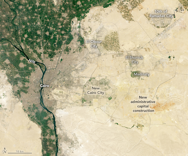
Cairo’s population boom has dramatically changed the city’s footprint. In addition to building upward and outward along the fertile floodplain of the Nile River, development has spread to several new satellite cities built on desert plains east and the west of the city. This pair of natural-color satellite images highlights new development to the east of the Nile River. The Thematic Mapper (TM) on Landsat 5 acquired the first image in 1984; the Operational Land Imager (OLI) on Landsat 8 collected the second image in 2019. With so many roads and buildings, densely developed areas appear gray. Undeveloped desert areas are beige. Farmland is green.
Close to the Nile River, much of the new development happened gradually as existing neighborhoods on the fringe of the city expanded into rural areas a little more each year. In contrast, the satellite cities in the desert appear abruptly, with large networks of roads and other infrastructure getting built-up all at once.
New Cairo is a prime example of a satellite city. Conceived in the early 1990s to help relieve congestion in Cairo, the first signs of the development became apparent in Landsat imagery in 1993 in the form of a large-scale network of new roads. After a few more years, several parks and golf courses appeared. In 2000, a presidential order designated New Cairo a city, and what had mainly been a grid of empty lots began to fill with schools, housing subdivisions, and shops.

Farther to the east, construction has begun on what some have called the “new New Cairo”—the future home of much of the Egyptian government. With the hope of creating a less congested and safer capital, the government plans to move more than 34 government ministries, including the presidential mansion, into the satellite city.
NASA Earth Observatory images by Lauren Dauphin, using Landsat data from the U.S. Geological Survey. Story by Adam Voiland.