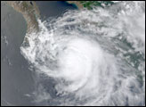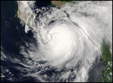

Hurricane Ignacio has continued to threaten the Baja California peninsula with high winds, heavy surf and the potential for flood-producing rainfall. Ignacio was declared a tropical depression at 5 am PDT (1200 UTC) on Friday, the 22nd of August, 2003 by the National Hurricane Center while it was 125 miles west of Puerto Vallarta, Mexico. It was upgraded to a tropical storm on the 23rd of August and became a hurricane at 2 am PDT, August 24th as it continued to move slowly northwest towards the southern tip of Baja California.
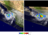
The Tropical Rainfall Measuring Mission (TRMM) satellite captured these images of Hurricane Ignacio when it was just 50 miles off of the southeastern coast of Baja California near the southern tip of the peninsula. The images were taken at 10:25 am PDT (17:25 UTC) on the 24th of August. At the time Ignacio was classified as a category 2 hurricane by the National Hurricane Center with sustained winds of 105 mph. The image on the left shows a plan or top down view of the storm in terms of rainfall rates from the TRMM Precipitation Radar (PR) in the inner swath and the TRMM Microwave Imager (TMI) in the outter swath overlayed on TRMM Visible Infrared Scanner (VIRS) data (white areas). It shows that Ignacio has a closed eye but that the storm is still very assymmetrical with all of the intense rainfall (darker reds) on the north and east side of the storm, indicative of a storm that is not yet completely organized. The image on the right shows an east-west vertical slice taken by the PR through the center of Ignacio that again shows the heaviest rainfall on the right or eastside of the storm (darker reds) as well as a tall tower known as a chimney cloud on the eastern eye wall that indicates the release of a lot of heat energy which powers the storm.
Images produced by Hal Pierce (SSAI/NASA GSFC) and caption by Steve Lang (SSAI/NASA GSFC).
As Hurricane Ignacio was churning in the waters near Baja, California, the TRMM and GOES satellites captured this image.


