| |
Koren paced, tapping his chin thoughtfully with his fingertips as he searched for the right words to convey the challenges he faced in the next phase of his research. “It is one thing to see with your eyes that smoke kills clouds,” he began. “It’s another thing to measure it.”
First, the team had to make sure that the absence of clouds in the smoky areas was not due to differences in meteorology. They accessed weather data—temperature, humidity, wind speed and direction at various barometric pressure levels, etc.—from the National Centers for Environmental Prediction (NCEP). Once they determined what the average weather conditions were like over the Amazon Basin during the dry season in 2002, they then looked for days in which there were anomalous conditions, such as frontal systems passing through or other shifts in meteorology that might have influenced the cloud patterns. They did not analyze Aqua data on any of the days in which they saw anomalous weather. On most of the days, the NCEP weather data proved that the meteorological conditions were exactly the same in the smoky regions as they were in the cloudy regions. So they knew the smoke had to be the reason why average cumulus cloud cover dropped from forty percent to zero in the presence of heavy smoke. |
|
  |
 |

“During the dry season,” Koren explained, “you can see clouds form in the morning in the east and by early afternoon the whole Amazon Basin—from the east to the Andes Mountains—is covered by cumulus clouds.” The main sources of humidity for forming these clouds are: windblown moisture carried by strong sea breezes from the Atlantic, and the upward transport of moisture from the surface. The steady flows of moisture into the air over the rainforest make it a very cloudy place, even during the dry season. |
|
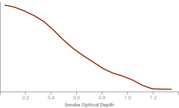
Satellite data for the western Amazon show a reduction
in cloud cover with increasing smoke optical depth. Cloud cover is about 40 percent with no smoke, and
is reduced near zero at a smoke optical depth of 1.2. (Optical depth is a measurement of the amount of
smoke. An optical depth of 0.1 indicates a relatively clear day with visibility more than 40 km. An
optical depth of 0.5 is quite hazy, and visibility is only about 10 km. An optical depth of 1.0 and
above would virtually obscure the sky from view.)(Graph redrawn by Robert Simmon from Koren, 2004) |
| |

Those clouds Koren had so loved back in college, however, became a major challenge when he returned his attention to the Aqua imagery. In order to determine which pixels in a given scene contained aerosols, he had to determine their “aerosol optical thickness,” which is a measure of how much sunlight the smoke prevented from traveling down through the column of atmosphere. This was nothing new; scientists have been accurately estimating aerosol optical thickness using satellite data for decades.
“But when measuring aerosol optical thickness, you want to make sure you don’t have cloud-contaminated pixels,” Koren said. “Normally, you’re willing to throw away pixels just to be sure you’re not analyzing aerosol data contaminated by clouds. But in this study, we had to be able to measure aerosol optical thickness in the presence of clouds, and so we had to make sure we were detecting the clouds in a very precise way in order to determine which pixels were cloudy, which were smoke, and which clear-air pixels were actually clear and not confused with shadow from the clouds.”
To help them better identify cloud-free pixels, and measure aerosol optical thickness in only those pixels, the team turned to Vanderlei Martins, a physical scientist at NASA visiting from Brazil. Martins wrote a new algorithm for using Aqua MODIS data to detect clouds especially for this investigation. Martins’ algorithm trained the computer to clearly distinguish between cloudy and smoky pixels, allowing the team to move forward in their investigation.
“For this project, we had to stretch our ability to estimate the smoke’s optical thickness even in cloudy skies.” Koren said. “We found that in fully cloudy conditions, the average aerosol optical thickness was very small.” In other words, there was very little or no smoke in the cloudy patches.
Once they knew which pixels contained cumulus clouds and which contained smoke, they could calculate how much of the area was covered by each. They fed these aerosol optical thickness and cloud coverage data into a computer model to determine how the changing atmospheric conditions affected the region’s radiant energy budget. The team was surprised by what the model showed.
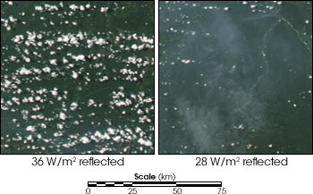
Given a square patch of Amazon Rainforest 100 km wide by 100 km long filled with an average coverage of scattered cumulus clouds, but containing no smoke, the clouds in the computer model reflected 36 Watts of sunlight back up through the top of the atmosphere for every square meter of surface area. On the other hand, when the same area was filled with heavy smoke and contained no clouds, the smoke reflected 28 Watts per square meter back up to space. In short, the model showed that the smoke increased the amount of solar energy added to the climate system equal to one 8-watt light bulb per square meter of surface area. This finding proved that aerosols don’t just cool the surface of our planet, but through the semi-direct effect they can also contribute to its warming. |
|
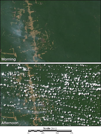
On a typical day during the Amazonian dry season the sky is clear in the morning, with clouds appearing in the afternoon. The clouds are formed by moisture that is carried from the ocean over the Amazon by the prevailing winds, evaporation, and the transpiration of the forest’s plants. These images were acquired by the MODIS intruments aboard Terra (top) and Aqua (lower) on August 3, 2003. (NASA Images by Jesse Allen and Robert Simmon) |
| |

Koren explained that during the Amazon burning season, when smoke fills the top of the boundary layer, the smoke particles absorb incoming solar radiation and warm the air while reducing the sunlight reaching the surface. This stabilizes the air near the surface, thus weakening or eliminating the upward movement of warm air (convection) and choking off the flow of moisture needed to form clouds. Then, because there is less cloud cover, more sunlight passes through the atmosphere and warms the surface much more than it would have under the cover of widely scattered cumulus clouds.
Does the aerosol semi-direct effect cause only short-term warming, and over only limited areas? Or, could absorbing aerosols possibly contribute to longer-term warming, and on a global scale?
 The Big Picture on Aerosols The Big Picture on Aerosols
 Aerosols: Particles of Many Personalities Aerosols: Particles of Many Personalities
|
|
The reduction of clouds due to smoke leads to less sunlight being reflected and more sunlight being absorbed by the Earth, resulting in warming. Areas with normal conditions of 40 percent cloud cover reflect 36 Watts per meter squared, compared to 28 Watts per meter squared for smoke-covered areas without clouds. This is contrary to the previously accepted theory that aerosols cool the Earth’s climate. These images were acquired by MODIS aboard Aqua on August 3, 2003. (NASA Images by Jesse Allen and Robert Simmon) |

