
Located in the Indian Ocean more than 1,000 km east of Madagascar, Piton de la Fournaise volcano on Reunion Island (21.2°S, 55.7°E), is a basaltic shield volcano very similar to Kilauea volcano (Hawaii) in terms of magma chemistry, the type of eruptions that occur, and the frequency of activity. Piton de la Fournaise typically erupts about once a year, and already this trend continues in 2002 with a major eruption that began on Saturday, January 5, at 11 p.m. local time. Many examples of rapidly-moving lava channels running down the center of active flows can also be seen in the photographs accompanying the web site and other sites listed below. The recent Piton de la Fournaise eruption stopped at 7:10 p.m. local time on Wednesday, January 16. |
|||
 | |||
NASA satellite data provide a unique perspective on the volcano and
the current eruption. Archival Landsat 7 ETM+ data (below) give a fine regional perspective of
the entire island, and many of the recent lava flows are visible as
dark-looking lobate features. Specific
characteristics of this year’s eruption have also been identified using
NASA’s Terra satellite. A thermal anomaly from the eruption was first
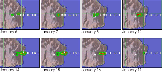
detected by the Moderate Resolution Imaging Spectroradiometer (MODIS) sensor aboard Terra on January 6. The University of
Hawaii’s MODIS thermal alert web site
identified both the eruptive fissure and the active lava flow as it
headed towards the coast. Additional MODIS scenes for the next two
weeks document the activity, with thermal anomalies being particularly
strong all the way from the vents to the coast on January 14 (bottom).
Although the eruption stopped on the 16, MODIS detected higher-than-normal radiance
values on January 17. |
The above photographs were taken during the Spring 1998 eruption. From left to right: The summit of Piton de la Fournaise, the dark streaks near the summit are 20th Century lava flows; glowing cinders erupt from Piton Kapur, a cinder cone in Piton de la Fournaise’s caldera; lava flows from Piton Kapur; vegetation bursts into flame as a lava flow advances. Further images from this series are available from Stromboli On-Line: Piton De La Fournaise. Photographs copyright Marco Fulle, Stromboli On-Line | ||
|
Landsat 7 ETM+ image of Reunion Island (upper). These data were obtained June 19, 2000. The insert shows the area of coverage for the lower scene. The red dot in the lower panel shows the approximate location of the vents on January 5, 2002. [Images courtesy Peter Mouginis-Mark (University of Hawaii)] | ||
Remote sensing volcanologists can use MODIS data to measure
not only the average temperature of the lava flow, but also to determine
the rate at which the magma is coming out of the ground. Such
information, when available in near real time via the on-line MODIS Land
Rapid Response site or
the MODIS Direct Broadcast capability, can be used to provide assistance
to disaster managers on Reunion Island or anywhere that a volcano erupts
because the final length of a flow is determined by the rate at which
magma reaches the surface. Quantitative analysis of the MODIS data for
the eruption of Piton de la Fournaise has not yet begun, but it is
already evident that Terra has provided a valuable new perspective on
this eruption. |
|||
 | |||
Additional remote sensing images of Piton de la Fournaise (including SIR-C radar data collected in 1994) can be found at the EOS Volcanology Science Team web site. Contact information: The data used in this study are available in one or more of NASA's Earth Science Data Centers. |
Time-series views of the MODIS thermal anomalies (red dots ringed in green) associated with the January eruption, as displayed on the University of Hawaii’s MODIS web site. [Images courtesy Peter Mouginis-Mark (University of Hawaii)] | ||