Remembering the Drought of 1988 |
|||
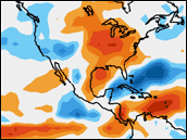
The Pacific La Niña was
intense in 1988. Scientists observed a series of processes that the
cold surface temperature anomaly set into motion that made it directly
responsible for the severe North American drought in the Great Plains
region (Trenberth and Guillemot 1996; Mo et al. 1997; Dai et al. 1998).
They found that the atmospheric circulation patterns leading to the dry
spell began in April of that year, about 10 days before the onset of the
drought, and persisted through June (Mo et al. 1997). Scientists also
measured anomalously low values of outgoing longwave radiation (heat)
over the eastern Pacific near Central America, signaling a northward
shift of the ITCZ. At the same time, there were unusually high levels
of outgoing longwave radiation over the Gulf of Mexico, the southeastern
United States, and northeastern South America. Scientists have observed
similar anomalies in outgoing longwave radiation in 16 of the last 19
major drought events in North America (Mo et al. 1997), suggesting there
is a relationship between them and drought episodes. |
| ||
|
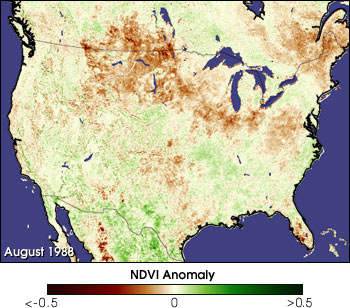
This NOAA Advanced Very High Resolution Radiometer satellite image shows where anomalously low (brown pixels) and high (green pixels) plant growth occurred in August 1988. Brown regions show drought and green show where the plants are thriving due to unusually high levels of rainfall. The summer of 1988 was North America’s worst drought on record since the infamous “dust bowl” years of the mid-1930s. (Image courtesy NASA Goddard Space Flight Center Biospheric Sciences Branch) | ||
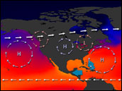
During La Niña years there is usually a weakening of the lower level jet stream that typically brings moisture into central North America from the Gulf of Mexico. A large anti-cyclone (or high-pressure system) often forms over the Great Plains, characterized by winds rotating clockwise (in the Northern Hemisphere) at about 10 meters per second or less. Air masses within the anti-cyclone tend to sink vertically downward and, upon reaching the ground, diverge outward away from the center of the system. This general sinking of the air inhibits the formation of clouds and precipitation. It is the anti-cyclone over the Great Plains that blocks or weakens the lower level jet stream and, thus, prevents or inhibits the transport of moisture into the region from the Gulf. Anti-cyclones tend to move in the direction of strong sources of warm air advection. (Here, "advection" refers to the horizontal movement of air masses.) In the U.S., then, anti-cyclones usually travel toward the east or southeast, sometimes transporting their dry conditions with them. Interestingly, the mid-western dry spell in the summer of 2000 shifted southeastward toward Georgia and Florida in early July. There are a number of other interesting parallels between the summers of 1988 and 2000. The first part of 2000 saw the remnants of a strong La Niña in the Pacific along with anomalously low springtime snow cover over North America, which contributed to very dry soil conditions in late winter and early spring. As temperatures warmed, very little moisture was available for evaporation to help offset the oncoming heatwave. And, still under the influence of La Niña, the prevailing atmospheric circulation patterns didn't bring moisture into the region, so the vicious drying cycle plunged regions of the mid-west headlong into a severe drought for most of the spring and summer.
|
|
alert message