
Explaining Upwelling |
|||
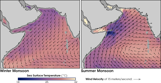
“At this point,” explained Goés, “we backtracked to winds as an explanation for the increased upwelling and cool sea surface temperatures.” Why are the winds important? Goés provides a mini-lecture on the climate of Southwest Asia. In Southwest Asia, the cycle between the winter and summer monsoon dominates the climate. In the summer, the winds blow from the ocean toward the land, bringing heavy rains to India, Pakistan, Bangladesh, and Myanmar among other countries. In the winter, the direction of the winds reverses, with winds blowing from land to sea. The seasonal reversal of the monsoon has dramatic effects on the Arabian Sea because the sea is landlocked to the north, isolating it from large-scale ocean circulation patterns. “When the Southwest Asian Monsoon is underway in June, July, and August,” explained Goés, “the winds blow from the southwest across the Arabian Sea, and the surface waters are pushed toward Asia. Cold water wells up along the coast of Somalia and the Arabian Peninsula to replace waters pushed ashore.” The most likely explanation for the cool sea surface temperatures off Somalia and the Arabian Peninsula that Goés and his colleagues had discovered was that upwelling had increased. The most likely explanation for increased upwelling, they reasoned, was a stronger Southwest Monsoon. |
|||
 | |||
|
To verify what was behind the upwelling, Goés worked with Prasad Thoppil, an ocean circulation modeler from the Naval Postgraduate School in Monterey, California. Using observations of wind speed and direction, they reconstructed maps of surface winds over the Arabian Sea over the same 7-year span. “We confirmed that the winds during the southwest phase of the monsoon had definitely picked up,” said Goés. |
In the summer, strong and steady monsoon winds drive the surface waters in the western Arabian Sea northeast. In response, cold water wells up from the ocean depths. These maps show sea surface temperatures (color) and winds (arrows). (Maps by Robert Simmon, based on data provided by the Bigelow Laboratory for Ocean Sciences) | ||
 |

Goés could have stopped hunting for an explanation at this point. After all, he had only started checking this scientific “string of lights” to find the burned-out bulb responsible for shorting out his global nitrate maps. A strengthening of the summer monsoon and a dramatic increase in plant productivity would have been an adequate explanation for why nitrate concentrations in his maps were so much higher than anything published before; his maps were unusual because the conditions in the Arabian Sea were unusual. But by now, Goés was tangled in the web of relationships that connect the land to the ocean to the atmosphere in Southwest Asia. Each question he asked and answered led to another, and like most scientists, Goés just couldn’t stop asking himself “Well, now what could be causing that?” If phytoplankton increased between 1997 and 2004 because upwelling had increased, and if upwelling had increased because monsoon winds had picked up, then the obvious question to Goés was why had the winds picked up? |
The force of wind (measured in newtons per square meter) on the surface of the Arabian Sea during the height of the summer monsoon (dark segments) has increased since 1997. The increased winds drive the upwelling of cool, nutrient-rich water, which in turn encourages the growth of phytoplankton. Knowing this, Goés was still curious: why was the wind getting stronger? (Graph by Robert Simmon, based on data provided by the Bigelow Laboratory for Ocean Sciences) | |