
| A Deadly Cycle | |||
|
"The thing that makes hurricanes tick is the warming of the upper atmosphere in the eye of the storm. This heat comes from the condensation of water vapor into cloud droplets," says Jeff Halverson. He is a meteorologist at NASA's Goddard Space Flight Center who has spent most of his professional life studying hurricanes. He explains that hurricanes are essentially a ring of thunderstorms swirling around the eye of the storm. To keep going, these thunderstorms need a continuous supply of water to replace what they lose in the form of raindrops. They are replenished by evaporated water that condenses in the air above the hurricane to form cloud droplets, which are then subsumed by the thunderclouds.
|
|||

Though water vapor in the atmosphere may seem harmless, en mass it contains an enormous amount of energy. The energy comes from the sun, which initially excites the water molecules on the surface of the Earth and causes them to evaporate. Each time a little of this water vapor comes together in the air to form a cloud droplet, the process of evaporation is essentially put in reverse and a little energy is released into the atmosphere in the form of heat. While the release of heat to form one raindrop is miniscule, the amount of heat released to replenish the cloud droplets in a hurricane is massive. It is this heat that drives a hurricane. "The rapid spinning motion of the hurricane keeps this heat in the center of the storm," says Halverson. The heat causes the air in the upper reaches of the hurricane eye to warm and expand vertically in the center of the hurricane, creating a reduction in pressure near the surface. To fill this void, air at the ocean surface streams inward toward the eye. Much like a giant vacuum cleaner, the hurricane's eyewall sucks up air from the ocean's surface, giving rise to the spinning motion of the hurricane and drawing in even more evaporated water from the surface of the ocean. The fresh evaporated water from the sea's surface then typically travels up through the hurricane's eyewall and splays out at the top where it cools and condenses. The formation of ice particles below freezing temperatures releases more heat energy and adds more water to the thunderclouds, often times causing them to grow even bigger. "So hurricanes are like car engines. The fuel is evaporated water on the ocean's surface. The cylinders are the thunderclouds inside the eye wall. They take in the fuel and convert it into heat energy which keeps the hurricanes alive," says Halverson. As long as the hurricane encounters new sources of moist sea air as it moves above the ocean's surface, it will continue to thrive.
|
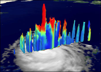
This TRMM Precipitation Radar image of Hurricane Bonnie, acquired August 22, 1998, shows where the highest concentrations of precipitation are within the storm. The red areas indicate the highest levels of precipitation, yellows show intermediate values, and blues indicate lower values. The highest level of precipitation, indicated by the prominent red "finger" in the center, is from a convective burst towering 11 miles into the atmosphere. (Image produced by Shirah/Morales, NASA GSFC; data courtesy NASA/NASDA) click to enlarge (243kb) | ||

|

Without a steady supply of evaporated water, however, the big thunderstorms that make up a hurricane would eventually empty their contents into the ocean and the low-pressure system at the center of the hurricane would die out. Cold waters that haven't been heated by the sun and land surfaces in general do not produce much evaporated water. So a hurricane will fade away if the water is less than 26.5 degrees Celsius (79.7°F) or if the hurricane makes landfall (University of Illinois, 1998). But if the hurricane wanders over an area of the ocean where the sea's surface has been heated and the air is humid and stagnant, the thunderclouds can grow extremely violent in a matter of hours. The worst possible situation, Halverson explains, is when hurricanes undergo what is known as a "convective burst." In this instance a sort of positive feedback loop is triggered wherein the hurricane passes over a large pool of warm water, grows more intense, draws in more moist air, gets even nastier and so on until it reaches Category 4 or Category 5 strength. "Once one of these convective bursts gets going it can last ten hours or more," says Halverson. This is what happened with Hurricane Opal in 1995. It also occurred in the South Pacific in 1997 when Tropical Storm Paka suddenly intensified and became Super-Typhoon Paka. The typhoon was so powerful that it even shut down the Joint Typhoon Warning Center in Guam.
|
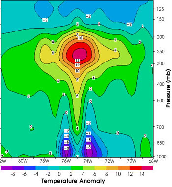
This graphic plots data from NOAA's Advanced Microwave Sounding Unit (AMSU) and shows a cross-section of Hurricane Bonnie to reveal its internal temperatures as a function of altitude and atmospheric pressure (both Y-axes), and as a function of west longitude (X-axis). The false colors represent temperature, with pink and red showing the highest values, greens and blues are intermediate values, and purples are the lowest values. Notice the high temperatures toward the upper central part of the hurricane, which are due to the latent heat being released from the water vapor being drawn upward from surface. The colder areas toward the lower central part of the storm are caused by the relatively cold rain drops. (Image courtesy Mitch Goldberg, NOAA [published in Kidder et al. 2000]) | |