
 by John Weier October 12, 2000 | |||
|
Despite the forecasts that Hurricane Opal would hit their town in a little more than 24 hours, the residents of Pensacola, Florida, remained relatively calm on October 3, 1995. They pulled their boats out of the water, boarded up the beachfront businesses and went about their daily routines, fearing no more than perhaps a few fallen trees and a missed day of work. At that time, the National Hurricane Center predicted that Opal would remain a Category 1 storm, packing peak winds of around 90 miles per hour—a veritable creampuff as far as hurricanes go.
Then overnight, as the hurricane moved across the Gulf of Mexico towards the city, something happened that no one predicted. The hurricane gathered energy from some then unseen reserves, jumped up in intensity to a strong Category 4 storm with peak winds of 150 mph, and threatened to turn Pensacola into a deluge of seawater and rain. The whole region went into a frenzy. The residents gathered what they could, evacuated their homes, and lined up bumper to bumper on Interstate 110 in an effort to flee. Though the storm dropped down a notch to Category 3 when it made landfall, Opal ended up being the fourth costliest hurricane in U.S. history, totaling $3 billion in damage and claiming four lives. Many feel that this loss of life and property damage could have been avoided if folks had been alerted of the storm's possible change in intensity the day before.
|
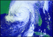
 This GOES image shows Hurricane Opal as it sweeps over the Gulf Coast of the United States on October 10, 1995. Image produced by the NASA GSFC Laboratory for Atmospheres using data from GOES-8. click to enlarge (209kb)
Also see:
| ||
|
What happened to the forecast and the forecasters? The National Hurricane Center (NHC) was at full alert and the personnel were monitoring the storm as best they could. The problem was that there was very little the forecasters could do to predict such a jump in intensity. While over the years government agencies have gotten more proficient in tracking storms and predicting their paths, they have not really gotten a handle on how intense the storms are going to be as they travel. Forecasting intensity requires a better understanding of the ongoing physical interactions between the ocean and atmosphere within the storm. Researchers need the ability to see through the cloud cover and into the hurricane as well as the ocean below it. Satellites and research aircraft have only infrequently been able to peer through the heavy cloud cover, so scientists have gotten too few data from inside hurricanes to fully understand how they work. Over the next few years, however, this may change. With the launch of NASA's Tropical Rainfall Measuring Mission in 1997 and several other weather satellites that can actually measure what goes on inside of cloud formations, scientists now have the tools to determine what causes a hurricane to intensify or weaken and to predict how intense a given storm will be as much as a day in advance.
The data used in this study are available in one or more of NASA's Earth Science Data Centers. |
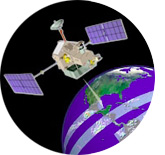
 The Tropical Rainfall Measuring Mission (TRMM) is the first mission dedicated to measuring tropical and subtropical rainfall through microwave and visible infrared sensors, and includes the first spaceborne rain radar. (see TRMM Fact Sheet)
| ||