
Clouds as a Patchwork Quilt | |||
In a satellite image, actinoform clouds look like distinct leaf-like or spokes-on-a-wheel patterns that stand out from the rest of the low-lying cloud field. Bjorn Stevens, a meteorology professor at UCLA, describes them as being similar to a “leaf floating in a pond.” Embedded within the low-lying clouds that give rise to what Southern Californians call May Gray and June Gloom, actinoform clouds have a distinct pattern that doesn’t fade away towards infinity, he said. “Imagine your grandmother’s quilt where one of the squares really stands out as being something different,” said Stevens. Like the square in the quilt, the cloud will hold its shape and stand out from the rest, he explained. “It will move with the wind, but it doesn’t grow or contract very much—it just has its own life,” he said. |
|||

Actinoform clouds are not a recent discovery; they appeared in meteorological literature as far back as the early 1960s, when the first weather satellites began sending back images. But until the late 1990s, scientists had dismissed them as merely a transitional form between other, more familiar types of clouds, and they were all but forgotten. In fact, the term “actinoform” isn’t included in the 2000 edition of the Glossary of Meteorology, which is considered to be the comprehensive reference manual for meteorologists. “There’s also a recent review of all the research that’s been done in the past 20 years on low-level clouds, and they don’t even mention actinoform clouds,” said Garay. “People just kind of forgot they were there.” |
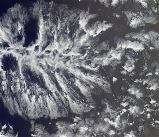
Like designs in a quilt, actinoform clouds stand out against a larger backdrop of cloud cover. In August 2001, the Multi-angle Imaging SpectroRadiometer (MISR) took this picture of actinoform clouds in the Southern Hemisphere. (Image courtesy NASA / GSFC / LaRC / JPL, MISR Team) | ||
 | |||
The NASA Langley Atmospheric Sciences Data Center (LaRC) played an important role in the rediscovery of actinoform clouds. Garay recalled that his advisor, Roger Davies, now at the Jet Propulsion Laboratory (JPL) in Pasadena, Calif., was looking through imagery from the MISR instrument, which the LaRC Distributed Active Archive Center archives and distributes. MISR collects data on the sunlit side of the Earth, using cameras that look in nine different directions simultaneously. The change in reflection at different viewing angles enables researchers to distinguish different types of atmospheric particles (aerosols), cloud forms, and land surface covers. Davies noticed a giant, leaf-shaped cloud that took up almost the entire width of one image, recalled Garay. “This sent me on a very interesting chase through the meteorological literature looking for pictures of these clouds, because as good as these database searches are—and they get better all the time—it’s hard to put in a search term like ‘cloud that looks like a leaf’ and get the right information, much less come up with the right picture,” said Garay. |
Featured in a MISR Mystery Image Quiz in March 2005, this image shows an actinoform cloud from space. (Image courtesy NASA / GSFC / LaRC / JPL, MISR Team) | ||
 | |||
Garay eventually tracked down satellite images of actinoform clouds taken by early weather satellites in the 1960s. But what he uncovered about the clouds themselves was quite unexpected. Actinoform clouds had been thought to be a relatively uncommon transitional form. However, by sifting through MISR images of the western coast of Peru, Garay found that actinoform-like clouds showed up roughly a quarter of the time as distinct formations within the more common, stratocumulus clouds in that region. Closer examination showed that actinoform clouds occur worldwide in nearly every region where marine stratus or stratocumulus clouds are common, particularly off the western coasts of continents—especially off Peru, Namibia in Africa, Western Australia, and Southern California. Such cloud systems are persistent year-round off the coast, yet in certain seasons they blow ashore and create the gloomy “May Gray” effect on land. And to Garay’s astonishment, the closer he looked at the clouds, the more complex he found their patterns of organization to be. “This is something you wouldn’t expect,” said Garay. “We don’t have a good understanding of why they have this radial structure to them and why it’s fairly common.” |
The National Oceanic and Atmospheric Administration (NOAA) operated a series of satellites in the Television Infrared Observation Satellite Program (TIROS) in the 1960s. These satellites captured several images of actinoform clouds. Images shown here were taken on August 16, 1962 (far left); October 7, 1962 (second from left and center); and July 18, 1964 (second from right and far right). | ||