The Earth Observatory has published its last Image of the Day on this website. Please join us on our new home at science.nasa.gov/earth/earth-observatory.
Hidden Impacts of Fires and Logging | |||
Cochrane and his team looked back at satellite images of deforestation in the Paragominas region of Brazil, one of numerous settlements along the “Arc of Deforestation,” on the developing frontier of the southern Amazon. The obvious deforestation that appears in high-resolution satellite images, such as those from NASA’s Landsat satellite missions, is the basis for Brazil’s assessment of human impact on the forest. Between 1993 and 1995, satellite images suggested a dramatic jump in the rate of Amazonian deforestation. The scientists wanted to know whether that jump might have been due not to intentional, slash-and-burn deforestation, but rather to accidental fire during the 1992 El Niño-induced drought. |
|||
 |
 |
In 1994-95, the annual rate of deforestation in the Amazon appeared to almost double over the rates of the previous two years. Cochrane and Nepstad believe this apparent jump was actually due to accidental fire following the 1992-93 El El Niño-related drought. [Graph by Robert Simmon, based on data from the Brazilian Instituto Nacional de Pesquias Espaciais (National Institute of Space Research)] | |
They pored over satellite images from the Landsat satellite captured between 1993 and 1995 to see what happened to all the area that was “deforested” in 1992. They decided that cleared areas with nice, straight lines that had sprung up next to pre-existing forest edges were probably intentional clearings for pasture or farmland. But Cochrane and his colleagues also discovered that much of the area labeled as deforested in 1992 was far from forest edges, was irregular in shape, and was already beginning to regrow. These areas, it seemed clear, were probably not the result of intentional deforestation. Instead, the scientists concluded, these tracts of forest had been “impoverished” by accidental fire. Cochrane estimated that accidental fires inflated the estimates of intentional deforestation during that period by 129 percent; in other words, more than half of what was called deforested during that time period was due to accidental fire. This distinction between accidental and intentional is important, explains Nepstad, because “it suggests that much of the impoverishment of the Amazon may have nothing to do with people’s plans for the land.” It gives governments and conservation groups a target for better land management that doesn’t immediately conflict with local land use needs. If the land was only burned accidentally, then on the surface at least, protecting it should not be as difficult as convincing a local land owner to give up his cattle pasture in the interest of forest conservation. The impacts of fires during the 1997-98 El Niño were dramatic and easily visible in satellite imagery, leading to an overestimate of deforestation for that time period. But unless an area has been repeatedly thinned through multiple burns, it may not be easily detected in satellite imagery. This is especially true of the small, first-time burns whose low-intensity presence sets the stage for future devastation. By failing to include these not-so-obvious burns, we may be seriously underestimating human impacts on the forest. In addition, we may be underestimating how greatly fire in the Amazon may be adding to global greenhouse gases. Nepstad says that during the last El Niño in 1998, the real amount of carbon emissions from fires in the Amazon may have been 200-300 million tons—nearly twice what scientists first thought. |
 Cochrane estimated that more than half of what was counted as deforested in 1994-95 was actually cleared by accidental fires. In satellite observations, such as the two example regions shown here, intentionally cleared forest areas had sharp, geometric edges (olive green shapes in top image) and usually extended from existing pasture (light yellow). Areas cleared by accidental fire (red, bottom image) had more ragged edges and were often far from developed land. The burned areas began to regrow shortly after the El NiNiño—another indication they were accidentally cleared.(Map adapted from Cochrane, 2000) | ||
 | |||
The hidden impact of accidental fire combines with another threat to forests: logging. Unless an area is completely deforested by loggers, it’s not likely to be labeled as such in Brazil’s annual tally. Partially logged or burned areas are visible in satellite imagery, but they begin to regrow so quickly that they are often overlooked in the annual estimate. Nepstad decided to try to determine how much undocumented, impoverished forest might exist throughout the Amazon. He and his colleagues combed though timber mill records and interviewed mill operators about how much wood they harvested between 1996 and 1997, and then they back-calculated the area of forest needed to provide that much wood. They went out into the field to verify that the records and their estimates were correct. Based on their research, Nepstad says that logging impoverished 10,000-15,000 square kilometers of undisturbed forest per year in 1996 and 1997, an amount that is at least half of the amount that was totally deforested during the same time. |
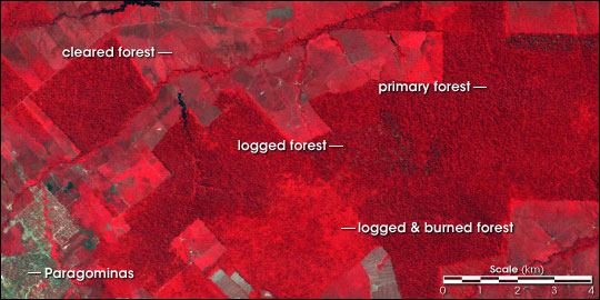
Selective logging and understory fires don’t completely destroy the rainforest, but instead degrade the forest. Satellite data, like the image above (composed of near-infrared, red, and green wavelengths of light) does not clearly differentiate untouched from degraded forest. Forested regions (dark red and textured areas) are easily distinguishable from cleared regions (light red or gray areas). The appearance of burned forest and logged forest is similar to primary forest. (Image by Robert Simmon, based on Landsat-5 Thematic Mapper data provided by the UMD Global Land Cover Facility) | ||
 | |||
Writing in a letter to the scientific journal Nature, Nepstad presents a stark picture of human impact on the Amazon: “Overall, we find that present estimates of annual deforestation for Brazilian Amazonia capture less than half of the forest area that is impoverished each year, and even less during years of extreme drought.” Drought may be becoming a more frequent occurrence in the Amazon, with the fires themselves adding insult to injury. The smoke released by biomass burning interferes with the Amazon’s great self-watering cycle, in which evapotranspiration from the forest feeds some of the clouds that add to the regional rainfall. More smoke equals less rain. Add to that the feeling of some experts that climate change may bring more frequent El Niño events, which amplify the seasonal droughts, and parts of the Amazon may be facing a much drier future. To help Brazil cope with droughts and fire, Nepstad and his colleagues use rainfall, soil moisture data, and satellite observations of the total solar radiation (which drives evaporation from the soil as well as evapotranspiration from vegetation) to model how much soil moisture is available to the forest during times of drought. They turn this information into Fire Risk maps that the Brazilian government can use for planning. In 2001, available soil water dropped to 50 percent of maximum over half the Amazon basin and to only 25 percent of maximum in about one third of the forests. When the available water drops below the 25 percent level, the forests’ leaf area is reduced by about the same amount. The thin canopy and dry leaves on the ground cause fire danger to skyrocket. One trigger can ignite thousands of square kilometers of forest. |
Standard deforestation analysis (above left) categorizes land as either forested (deep green) or cleared (beige). When Nepstad refined satellite observations using interviews with landholders, it became clear that much of the forested area around Paragominas was not undisturbed, but instead had been degraded by logging and accidental fire (above right). These images were derived from the Landsat scene above and show a wider view of the region around the town of Paragominas. Degraded forest can be easily destroyed by accidental fire and does not support the diversity of species of undisturbed forest. (Map adapted by Robert Simmon from Nepstad et al., 1999) | ||
