Fire Follows Fire | |||
The intentional fires have an all-too-frequent tendency to escape control. Fire steals into nearby forest, where it creeps its way through the understory. Understory fires have a radically different effect on Amazon forests than they do on forests in the western U.S. or the boreal forests of the North, which have evolved in the presence of fire. “When you burn a forest out West,” explains Nepstad, “future flammability of that forest goes down because they are big fires that go through and consume everything but the best-protected trees. In the Amazon, the first fires aren’t big enough or hot enough for that.” |
|||
The first fires are so small and low-key that Nepstad and his colleagues can walk alongside or step over them, but Nepstad describes the fires’ disastrous long-term effects. “Fire goes through and kills small, thin-barked trees, but doesn’t consume them. This creates a lot of dead wood. When the dead trees fall, they create openings in the forest canopy. Any time you punch a bunch of holes in the canopy and let the sunlight in—either through understory fires and the killing of trees, or logging, or drought—you increase fire risk. Unlike the forests out West, an understory fire in the Amazon causes the flammability to go way up.” |
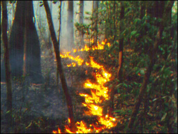
Fires in the Amazon start small—low, slow-moving blazes that feed on the thin layer of dead leaves and detritus on the forest floor. With natural fires so rare, occuring perhaps once every 1,000 years, even these small fires kill some trees. Once they fall, holes left in the rainforest’s protective canopy dry out the understory, setting the stage for a new round of more destructive fires. (Photograph copyright Woods Hole Research Center) | ||
To determine how great a risk fire poses to Amazonian forests, one of Nepstad’s Woods Hole colleagues, Mark Cochrane, undertook a field study of Amazon fires. Cochrane and several other scientists, including Nepstad, observed fires in study plots in the eastern Amazon before and after the severe El Niño-induced drought of 1998. Of the ten half-hectare forest plots (0.5 hectares is 5,000 square meters or 1.2 acres) in the Tailândia region of eastern Amazonia, eight had already been affected by fire at the start of the study, while two were undisturbed. All the team’s observations of fire characteristics, from intensity, to rate of spread, to how high into the canopy the fire reached, painted the same picture: in the Amazon, on the heels of every fire is another, more devastating blaze. |
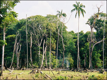
Clearings in the Amazon increase the flammability of the forest. Sunlight penetrates into the understory, warming and drying the forest floor, which is normally protected by the dense canopy. Selective logging, permitted on some protected forest land, also produces breaks in the canopy and increases fire risk. (Photograph Copyright Lucia Enriconi, Miami Museum of Science) | ||
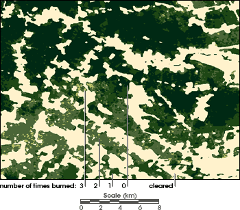
While only 23 percent of previously unburned forest in the Tailândia study area burned during the 1997-98 El Niño, the percentage jumped to more than 39 percent for areas that had already burned once before, 48 percent for areas that had burned twice already, and to a staggering 69 percent for those areas that had burned three times before the study began. The scientists began to realize that these multiple-burn plots of forest were so drastically thinned of trees that they almost appeared to be deforested, and they wondered what effect these accidentally fire-thinned areas might have on the Brazilian government’s annual deforestation estimates. |
Although virgin forest in the Amazon is resistant to fire, a single low-intensity fire increases the likelyhood and severity of additional fires. Scientists use satellite data to map burned areas and determine the number of times the forest has burned. This map shows a portion of the Tailândia region. Unburned forest is dark green, burned forests are progressively lighter and more yellow. Intentionally cleared areas are beige. (Map adapted from Cochrane, 2000) | ||
alert message
