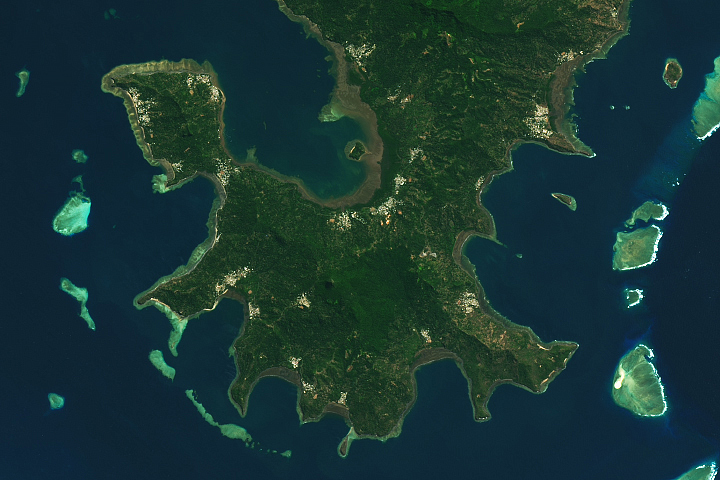
Update on March 29, 2023: This puzzler image shows the volcanic islands of Mayotte, the eastern-most islands in the Comoros archipelago. Congratulations to Mike for being the first reader to correctly identify the image. Read more about the location in our Image of the Day story.
Every month on Earth Matters, we offer a puzzling satellite image. The February 2023 puzzler is shown above. Your challenge is to use the comments section to tell us where it is, what we are looking at, and why it is interesting.
How to answer. You can use a few words or several paragraphs. You might simply tell us the location, or you can dig deeper and offer details about what satellite and instrument produced the image, what spectral bands were used to create it, or what is compelling about some obscure feature. If you think something is interesting or noteworthy, tell us about it.
The prize. We cannot offer prize money or a trip on the International Space Station, but we can promise you credit and glory. Well, maybe just credit. Within a week after a puzzler image appears on this blog, we will post an annotated and captioned version as our Image of the Day. After we post the answer, we will acknowledge the first person to correctly identify the image at the bottom of this blog post. We also may recognize readers who offer the most interesting tidbits of information. Please include your preferred name or alias with your comment. If you work for or attend an institution that you would like to recognize, please mention that as well.
Recent winners. If you have won the puzzler in the past few months, or if you work in geospatial imaging, please hold your answer for at least a day to give less experienced readers a chance.
Releasing Comments. Savvy readers have solved some puzzlers after a few minutes. To give more people a chance, we may wait 24 to 48 hours before posting comments. Good luck!
Tags: puzzler


I won’t give away the answer, but there’s an underwater volcano about 50km away that researchers say is causing this island great environmental damage.
Mayotte?
Google image search yields (near the top)
File:Mayotte,_vue_par_Sentinel_2_(cropped).jpg
The southern part of Mayotte, a French Island in
the Indian Ocean, is a near perfect match to this
month’s puzzle.
I’m looking forward to comments on why it is interesting.
Unhabitat island coral sea somewhere
This is the Kani-Kéli Peninsula in Mayotte Island, part of France. It is also relevant that the Forest Reserve South Crete as well as the Mayotte Marine National Park are shown in the picture.
12,95673° S, 45,13158° E
Thank You for your consistent and amazingly didactic imagery and explanations that you post on the website. I’m sure this curated knowledge brightens and inspires the minds of many in this spinning world of ours and for generations to come.
Papau New Guinea
Mayotte
Whilst the rest of the Comoros Islands voted for independence Mayotte stayed as a French run region.
This is the southern tip of Mayotte, Comoro Islands, France. The issue is an underwater volcano growing rapidy!
Mayotte ,in Indian Ocean
This is the island of Mayotte, which is in the Indian Ocean between Madagascar and Mozambique. (formerly part of the Comoros Islands, with historical ties to France)
There is a nearby undersea volcano that has been erupting.
Hi!
Well, due to time differences most probaly this has been answered allready.
If I am correct it is the southern part of Grande-Terre, Mayotte Island, out in the Indian ocean.
Well, it was no mistaking as the unique shape, NW off Madagascar, did appear in images tracking storm Freddy. The interesting part is that it is not just a reef atoll, but a volcanic island surrounded by a barrier reef. Personally, I think the southern penninsula has an interesting outline with the different bays offering quite a contrast to the “rounded” northern edge.
All the best,
Pieter van Gylswyk
island reefs most ubiquitous oceanic landform
This is the southern part of the island Mayotte (in the Indian Ocean channel between Madagascar and Mozambique), rising more than 3000m from the bottom of the sea, with ancient volcanic peaks, the highest at 660m above sea level.
The Mayotte Lagoon is one of the biggest lagoons in the world.
I believe it’s the south of the island of mayotte.
It’s the southern end of Mayotte island between Madagascar and Mozambique!
The image looks like it’s an optical image, maybe shot with a DSLR perhaps?
Mayotte, French overseas territory, Mozambique channel, Indian Ocean.
In this image, the south of Grande Terre, the main island of the archipelago.
Biggest closed lagoon in the world.
Fringing reefs as well as the double reef barrier (located in the south of the island) appear clearly in this image. Mangrove forests, too, especially in the bay of Bouéni.
At the bottom right of this satellite image, near Sazilé peninsula, two keys, little white sand islets, can easily be seen. The biggest is named ‘Mtsanga Tsohole’ in shimaore, one of the two languages spoken in Mayotte, which means “sand-rice” -due to a local legend.
Mayotte’s Lagoon
gewae
Mayotte’s Lagoon