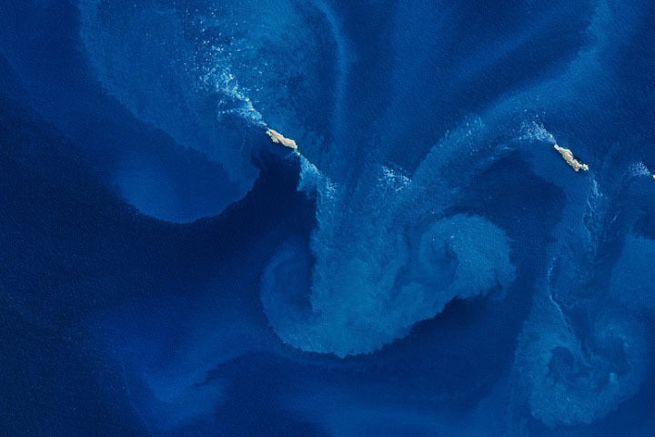
Every month on Earth Matters, we offer a puzzling satellite image. The November 2020 puzzler is above. Your challenge is to use the comments section to tell us what we are looking at, where it is, and why it is interesting.
How to answer. You can use a few words or several paragraphs. You might simply tell us the location, or you can dig deeper and explain what satellite and instrument produced the image, what spectral bands were used to create it, or what is compelling about some obscure feature. If you think something is interesting or noteworthy, tell us about it.
The prize. We cannot offer prize money or a trip to Mars, but we can promise you credit and glory. Well, maybe just credit. A few days after a puzzler image appears on this blog, we will post an annotated and captioned version as our Image of the Day. After we post the answer, we will acknowledge the first person to correctly identify the image at the bottom of this blog post. We also may recognize readers who offer the most interesting tidbits of information about the geological, meteorological, or human processes that have shaped the landscape. Please include your preferred name or alias with your comment. If you work for or attend an institution that you would like to recognize, please mention that as well.
Recent winners. If you’ve won the puzzler in the past few months, or if you work in geospatial imaging, please hold your answer for at least a day to give less experienced readers a chance.
Releasing Comments. Savvy readers have solved some puzzlers after a few minutes. To give more people a chance, we may wait 24 to 48 hours before posting comments. Good luck!
UPDATE on November 9 — The answer is a phytoplankton bloom near the Jason Islands, an archipelago off of the Falkland (Malvinas) Islands. Read more about it here. Evzen Schulc quickly identified that it was an ocean bloom, though no one managed to identify the location.


It is probably phytoplankton bloom in the North Sea.
This image is definitely a phytoplankton bloom somewhere in the sea
I am looking at two coastal ships that are looking at coral or pumice
I would think some sort of algal bloom with a strong northerly flow (assuming this photo is oriented north/south). The north flow is being blocked by the islands creating those nice eddies/spin-ups south of the islands.
Plankton Bloom, Black Sea
Rivers transport nutrient-filled urban and agricultural runoff into this inland sea, promoting phytoplankton blooms
Giant wave off Nazare, Portugal beginning to crest.
Es en Brasil, y son las olas más grandes del mundo, y es interesante por qué son enormes
Ocean currents marshal islands
Some of the fumes from the volcanoes could be from under the water and were formed in this view as a result of water currents
Water flowing past 2 islands then creates waterfalls.
tail of a whale as it breaking upwards out of the water… view from below
Submerged water falls in the ocean. They are simply created when two regions of fluid are of different density from salinity variations, temperature variations or both. The heavier fluid comes to contact with the lighter fluid and it generates a waterfall.
Hi Everyone @ NASA
from afar looks like a pair of Belluga Whales
with Plankton Dancing in Ocean?
Sorry I’m Not Sure which Ocean
Because of the Vivid Blue I’m Guessing
Pacific Ocean? Thank You ?
It looks to be a couple types of mountainous ranges that are purtruding through a mist of gases on the planet Venus, also like water to a rock wall over millions or billions of years shaped the landscape into a modern artistic view through the eyes of still picture you offer. November 5th 2020 1:24pm
Hi!
I think it’s a tornado at sea! Not sure where cos that colour is amazing!
The Fukushima Daiichi Power Plant spills radioactive liquid into the Sea of Japan 10 years later.
If the caps are white, then icebergs in ocean. If not then it could be ocean event like plankton or small spawning event. Are the ‘white caps” an elevation marker????
I have a feeling that this isn’t something anyone would be able to find on a map as it looks like a pair of pumice raft fragments – brown in colour, no vegetation, shape perpendicular to the current, and no sign of land submerged under the surrounding water.
Pumice rafts or “islands” form over submarine volcanoes, with buoyant gases trapped in the vesicles of the rock causing it to flow upwards during an eruption and collect at the surface in a simulation of dry land. Sometimes the layer is thin enough for a boat to sail through or sometimes thick enough to support human weight.
What looks like an algal bloom would actually be the pumice losing its gasses, becoming waterlogged and sinking back into the water column, slowly enough to drift and pattern the currents. This would explain why the discolouration appears to project from the ends of the rafts, rather than originating in the water as with an algal bloom—as the current moves the raft it would spread sideways in each direction, losing coherence as it does, and exposing more of the pumice to become waterlogged. The discolouration appears to fade outwards as the rock sinks back to the sea floor.
Pumice rafts are often found in the Pacific “ring of fire”, including the large raft that occurred near Late Island on the Tofua volcanic arc in August 2019.
It is an ocean wave!
A face that somehow formed by air & current. The spirit of the oceans of mother earth vehemently frowning at mankinds insolence.
Hi NASA. I’m sure. I see smiling sea 😉