Update: the answer to the June puzzler has been posted.
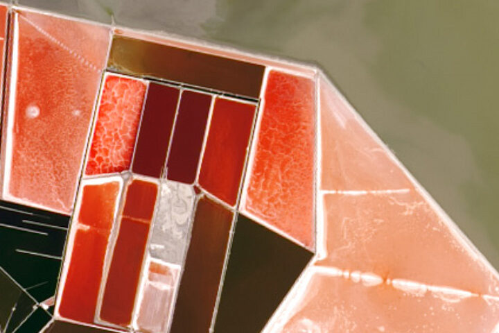
Every month on Earth Matters, we offer a puzzling satellite image. The June 2019 puzzler is above. Your challenge is to use the comments section to tell us what we are looking at and why it is interesting.
How to answer. You can use a few words or several paragraphs. You might simply tell us the location. Or you can dig deeper and explain what satellite and instrument produced the image, what spectral bands were used to create it, or what is compelling about some obscure feature in the image. If you think something is interesting or noteworthy, tell us about it.
The prize. We can’t offer prize money or a trip to Mars, but we can promise you credit and glory. Well, maybe just credit. Roughly one week after a puzzler image appears on this blog, we will post an annotated and captioned version as our Image of the Day. After we post the answer, we will acknowledge the first person to correctly identify the image at the bottom of this blog post. We also may recognize readers who offer the most interesting tidbits of information about the geological, meteorological, or human processes that have shaped the landscape. Please include your preferred name or alias with your comment. If you work for or attend an institution that you would like to recognize, please mention that as well.
Recent winners. If you’ve won the puzzler in the past few months or if you work in geospatial imaging, please hold your answer for at least a day to give less experienced readers a chance to play.
Releasing Comments. Savvy readers have solved some puzzlers after a few minutes. To give more people a chance to play, we may wait between 24 to 48 hours before posting comments.
Good luck!


Evaporative Mineral Ponds, salts and other minerals. Color is probably related to the specific mineral or alge growing in the ponds. Just and educated guess!
Those are salt dehydration ponds (possibly just west of Fremont CA).
Landsat-8 MSS, wastewater treatment plant
My guess – Yaiza, Las Palmas, Spain – kinda reminds me of Lake Magadi. 🙂
The image looks like an aerial photo of salt ponds! I grew up in the San Francisco bay area where we drove past some often.
Some sort of strawberry licorice field on a secret planet somewhere.
Desalination ponds somewhere along some coastline.
I see Star Trails on the left and Earth on the right I believe this is solar panels or reflector panels on the satellite interesting because of the different materials it’s made from
bauxite residue dewatering
Maybe some place where they extract salt from seawater?
Saline lakes.
Drain pond from some kind of mining or farming.
These are salterns. Sea water is brought into the large pools and allowed to evaporate in order to harvest salts for various purposes. As the water evaporates salinity increases creating a hypersaline environments which cause blooms of halophilic (salt-loving) microorganisms. These organisms contain various pigments which cause the red color. Halophiles are super cool organisms with a wide variety of impacts on life including: food production (soy sauce and other salty fermented foods), bacteriorhodopsin – the red pigment (optical nanodevices), and are candidates for extra terrestrial life (on Mars?).
Disclosure: I did my master’s thesis on salterns and halophiles.
These are salt pans. Should be near a salt water lagoon. The red colour of water is due to the high concentration of salts. Captured by Landsat 8, OLI sensor.
I was thinking lithium extraction/mining but the colour is off, so maybe it was taken with a different kind of satellite that skews colours.
Looks like heat shield panels from one of the now retired space shuttles.
Salt ponds in Botswana, Makgadikgadi Salt Pans.
Looks like a salt evaporation pond.
Sea salt evaporation ponds, maybe in San Francisco Bay.
aerial view of poppy fields in various stages.
maybe narcotics related
Salt evaporation ponds in San Francisco/San Pablo bay. Natural color.
Salt evaporation ponds in Camargue, France? The color comes from algae, which develop different colors as evaporation results in increased salinity.
Looks like specialty “outer camera plates” on the Space Station as it is capturing specific ingredients & colors of elements seen on earth in various locations; almost like tracing radiation particles; also the way light waves cause the colors in rainbows!
Always astonishing finds—NASA, the colors and textures are beautiful!
Those I believe are salt evaporation ponds.
I believe this is a natural color image of salt evaporation ponds.
Salt evaporation ponds
Salt evaporation ponds?
I believe it is a salt pond in natural color
Lithium salts evaporation ponds in the Ecuadorian highlands. Important because well who doesn’t use lithium ion batteries.
Saltworks. Where sea water is put in ponds and then the water evaporates off leaving behind the salt.
Aerial salt mining/evaporation ponds.
shrimp farm
Ice crystal
Salterns or salt lakes of Utah
I think they are salt pans, could be the Mediterranean, as I’ve seen them there that colour.
This is looking something like agricultural land.
Salt ponds in central Botswana known as the Makgadikgadi Salt Pans.
Salt ponds in central Botswana known as the Makgadikgadi Salt Pans.
37.504219, -122.038396; San Francisco Bay (East Bay), southeast of the Dumbarton Bridge. They are salt evaporation ponds. Been there for many, many years.
camera disturbed,those are metal plates of the station,just zoomed in,,,,,,,,,,,
Definitely salt water dehydration plant!