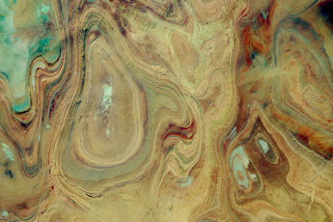
Every month on Earth Matters, we offer a puzzling satellite image. The November 2017 puzzler is above. Your challenge is to use the comments section to tell us what we are looking at, when the image was acquired, and why the scene is interesting.
How to answer. You can use a few words or several paragraphs. You might simply tell us the location. Or you can dig deeper and explain what satellite and instrument produced the image, what spectral bands were used to create it, or what is compelling about some obscure feature in the image. If you think something is interesting or noteworthy, tell us about it.
The prize. We can’t offer prize money or a trip to Mars, but we can promise you credit and glory. Well, maybe just credit. Roughly one week after a puzzler image appears on this blog, we will post an annotated and captioned version as our Image of the Day. After we post the answer, we will acknowledge the first person to correctly identify the image at the bottom of this blog post. We also may recognize readers who offer the most interesting tidbits of information about the geological, meteorological, or human processes that have shaped the landscape. Please include your preferred name or alias with your comment. If you work for or attend an institution that you would like to recognize, please mention that as well.
Recent winners. If you’ve won the puzzler in the past few months or if you work in geospatial imaging, please hold your answer for at least a day to give less experienced readers a chance to play.
Releasing Comments. Savvy readers have solved some puzzlers after a few minutes. To give more people a chance to play, we may wait between 24 to 48 hours before posting comments.
Good luck!


My guess: Toquepala Copper Mine, Peru
We are looking at a section of a satellite image that was acquired over south-central region (26.01,2.01) of Algeria in the Sahara Desert of North Africa. This region is largely uninhabited and is part of the Tanezrouft Sedimentary Basin. Former caravans avoided this place due to its lack of water and vegetation. I guess that is why this place is also known as the ‘land of terror’ and ‘land of thirst’. Those concentric and elliptical patterns of yellowish dark brown colors seem like ‘modern art’ but are actually outcrops; specifically these are types of folded sandstone rock formations which are geologically called synclines. The cyan white colors indicate salt flats.
Source: Google Earth, ESA, ISS Imagery
Algeria 26 02′ 50” N 2 10′ 50” E Sahara Desert
Salt pens – formed by evaporation of water – in a desert, where water evaporation exceeds the rate of precipitation. Water, unable to drain into the ground, remains on the surface and evaporates – minerals precipitated from the salt ions dissolved in the water are left behind – after thousands of years, minerals/salts accumulate on the surface – they reflect sun rays and appear white.
That’s right, thanks for the description.
Thank you for the knowledge. Ibwouldbt have a clue where this is.
Collarado usa
Death rally collarado usa
That’s right, Algeria. And very close there is a beautiful impact crater.
Great Salt Desert (Kavir e Namak)/Iran
Looking down at paint in a paint can, partially mixed.