Support from the Skies |
|||
Unexpected though the results may be, they are supported by satellite data. By choosing to model the upper troposphere, Dessler and Minshwaner were able to test their model against the data collected by two instruments on the Upper Atmosphere Research Satellite. The Microwave Limb Sounder (MLS) and the Halogen Occultation Experiment (HALOE) have been taking regular measurements of water vapor in the upper troposphere since late 1991, giving the scientific community its first look at what was actually going on over time in the upper troposphere. HALOE observes the way that sunlight passes through the atmosphere at sunrise and sunset. As the Sun rises, its light slices horizontally across the atmosphere. Stationed opposite the Sun, HALOE measures how the light changes as it passes through the atmosphere. This gives a vertical profile of the make-up of the atmosphere, including water vapor concentrations. The Microwave Limb Sounder measures naturally occurring microwave thermal emissions from the limb of Earth’s atmosphere to make a similar vertical profile of the atmosphere. Minschwaner and Dessler correlated these profiles of the upper troposphere with surface temperatures to determine the effect of temperature on relative humidity. “We are the first to use direct observations of water vapor in this region,” says Dessler. |
|||

They found that the water vapor content of the upper troposphere measured during the 1990s climbed as the Earth’s surface temperature rose, but not enough to maintain constant relative humidity, just as their model predicted. These observations give Dessler and Minshwaner’s results far more weight than they might otherwise have had. Richard Lindzen, the Alfred P. Sloan Professor of Meteorology at the Massachusetts Institute of Technology (Cambridge, Massachusetts) and a pioneer in the study of the water vapor feedback, acknowledges, “Regardless of the model [which he calls ‘not very conclusive’], the observations do make a case that the water vapor feedback above 200 millibars [12 kilometers] is likely to be somewhat positive.” |
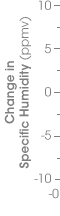
Instruments aboard UARS measure the concentration of gases in the atmosphere by looking through the Earth’s “limb”. This is the portion of the atmosphere that rises above the curvature of the Earth’s surface as seen from space. This vantage point allows instruments to measure the atmosphere at different altitudes. (Astronaut photograph ISS007-E-17719 provided by the NASA-JSC Gateway to Astronaut Photography of Earth) |
||
 |
Water in a Changing ClimateBut what do these results mean for the larger picture of climate change? “The climate implications are very limited,” Lindzen says. One of his main criticisms is that the upper troposphere doesn’t have much influence over the water vapor feedback of the entire atmosphere. The region between three and ten kilometers—where weather occurs—has a far greater impact on the Earth’s climate. “At the levels Dessler [and Minschwaner] are concerned with, there simply is not much water vapor,” says Lindzen. In response, Dessler argues that their conclusions almost certainly apply at 10 kilometers, where water does have a significant climate impact (although they only can only confirm the model’s behavior at 12 kilometers altitude). Still, Sherwood agrees with Lindzen. “The levels where they found something unexpected are making a relatively small contribution, so we might be talking about something like a ten percent weaker feedback effect than we thought.” But, when other influences on the climate are factored in, “that could still make a difference,” he adds. Folkins believes that Minschwaner and Dessler’s results might be used to refine the scientific understanding of water vapor feedback and the models that predict climate change. “It is important to understand water vapor both using simple process approaches and data, plus global climate models.” Unlike big climate models, Minschwaner and Dessler’s model can be tested and confirmed with satellite data, Folkins points out, and that makes it valuable to the scientific community. “I think it’s a pretty provocative and good paper because it should get people thinking more seriously about their assumptions on how water vapor will change in the upper troposphere.” “There is a certain sense of complacency that water vapor feedback is understood. And that comes from the fact that a lot of these global climate models agree with each other,” Folkins observes. “But just because they agree, doesn’t mean they are all right.”
|
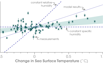
Measurements of water vapor taken by HALOE (green crosses) and compared with sea surface temperatures show a similar relationship to that predicted by Minschwaner & Dessler’s computer model (dotted line). Specific humidity rises with rising sea surface temperatures, but not fast enough to maintain constant relative humidity (angled dashed line). The pale green area is a best fit of the data, including uncertainties. (Graph adapted from Minschwaner & Dessler) |
|
