| Searching for Spotted Owls from Outer Space |
| |
 Discerning
the amount of potential owl habitat throughout the Pacific
Northwest is not as simple as gauging whether or not a group of trees is
conifer. "There are many layers and levels to this project,"
said Alegria. The researchers are now simply attempting to create a
reliable satellite vegetation map of the 25-million acres of land
specified by the FEMAT plan. When complete, the map should help
biologists identify areas of old-growth forest and potential owl
habitat. Discerning
the amount of potential owl habitat throughout the Pacific
Northwest is not as simple as gauging whether or not a group of trees is
conifer. "There are many layers and levels to this project,"
said Alegria. The researchers are now simply attempting to create a
reliable satellite vegetation map of the 25-million acres of land
specified by the FEMAT plan. When complete, the map should help
biologists identify areas of old-growth forest and potential owl
habitat.
Karin Fassnacht, a research forester at the U.S. Forest Service,
works with Alegria to develop these maps. She explained, the
scientists’ goal is to use Landsat satellites to map a number of
attributes of forest vegetation across the Pacific Northwest. These
attributes include the density of forest vegetation, the amount of
conifer trees, the amount of broadleaf plants, the average size of the
trees, and the complexity of the forests’ structure. Each of these
cover variables will appear on the finished Landsat maps in terms of
percentage, she said. |
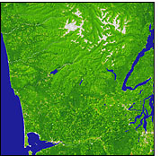
This simple vegetation map (a portion of Washington State) only shows the amount of vegetation present. Clearcuts and barren mountaintops (shown as gray and brown) are easy to spot, but there is no way to distinguish conifers from deciduous trees or to determine the age of the forest. Click to see a 3D flythrough. (2.1MB) (Image and animation by Robert Simmon, based on North American Landscape Characterization data) | |
 So far, the
scientists have found ways to combine the colors from the
Landsat images to locate four out of five of these forest attributes on
a given strip of land. "We are currently unable to map structure
at all [using the satellites]," said Fassnacht. So far, the
scientists have found ways to combine the colors from the
Landsat images to locate four out of five of these forest attributes on
a given strip of land. "We are currently unable to map structure
at all [using the satellites]," said Fassnacht.
When the maps are fully developed, they may help scientists determine if the trees in a section of forest are old. High percentages of large conifer trees with greater structural complexity usually indicate old-growth forest in the Pacific Northwest. By looking for these attributes on the satellite map, researchers should be able to locate areas likely to contain old-growth forest. "Additional ground-based or photo-based measurements must then be made to determine if any old-growth exists," said Fassnacht. In the same manner, the maps may assist researchers in determining where owls and other animal species might exist. Those who know how the owls live could use the map, in part, to pick out those areas that have the percentage of conifer growth, structural complexity, and tree sizes required for the bird to survive Fassnacht said. These areas of potential habitat could then be verified on the ground. With enough effort, the scientists should be able to map out all the areas where northern spotted owls could possibly live in the 25-million acres. The same could be done for other threatened species in the old-growth forest, such as the marbled murrlet. "There are several ongoing projects aimed at mapping habitats," Fassnacht said. The BLM and USFS have just recently put out their first satellite-imaging map of the forests along the Coast Range, said Alegria. Though the map does not contain the structural complexity of the forests, it shows promise. Within the next few years the team hopes to have mapped the entire 25-million-acre plot of land specified by the federal plan. Not long after that, a map of all the potential owl habitats of the Pacific Northwest should be complete. |
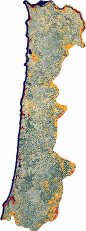
Dark green areas on this map exhibit the characteristics
of old growth forest, which are large trees, dense vegetation and a make-up of at least
thirty percent conifer. The final feature - canopy
complexity - may be measured by NASA's upcoming Vegetation Canopy Lidar mission.
(full size map) (Image by Janine Savage, Global Change Master Directory, based on data
from the Interagency Vegetation Mapping Project)
|