
Population’s Impact on Nature | |||
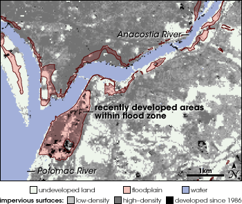
In addition to increasing the cost of natural disasters, population growth and the landscape changes that go with it may make some disasters more severe. When a swath of trees becomes a neighborhood or an office building, the ground changes from spongy, water-absorbing soil to impervious pavement. Rain that would otherwise have soaked into the ground now has nowhere to go, and runs off as flood water. When land is deforested and remains bare or sparsely vegetated, soil erosion can worsen flooding. Rapidly increasing population puts additional strain on water supplies during times of natural drought. Impervious SurfacesClaire Jantz, a researcher at the Woods Hole Research Center, has observed urban growth in Landsat satellite images of the Baltimore-Washington area collected between 1986 and 2000. NASA funded Jantz to work with Steve Prince (University of Maryland) and Scott Goetz (The Woods Hole Research Center) and other colleagues to produce maps of impervious land surfaces and vegetation in the Chesapeake Bay watershed using Landsat data. Because impervious surfaces tend to be man-made, the maps reveal the effects of population growth. Jantz was stunned when she compared the impervious surface maps to maps of flood zones published by the Federal Emergency Management Agency (FEMA). |
|||

“It was a surprise to see how much development occurs in flood zones,” Jantz recalls. “To see large areas of pavement within a flood zone is impressive.” In 1990, 450 square kilometers (111,200 acres) of developed land lay in Special Flood Hazards Areas—100-year flood zones, where there is at least a one percent chance of complete or partial flooding in any given year. By 2000, the figure had grown to 767.7 square kilometers (189,700 acres), an increase of nearly 71 percent. Jantz acknowledges that the figure is an estimate. It could be higher if additional development exists in the 38 percent of the Chesapeake watershed not covered by FEMA’s flood maps. It could be lower if some of the “new” impervious surfaces detected in 2000 had been there all along, but were detected for the first time because of quality improvements in Landsat 7 data compared to the Landsat 5 data from 1990. Finally, naturally impervious surfaces like beaches and bare rock undergo natural changes that can be confused with development. Even as she acknowledges these uncertainties, Jantz reports, “The magnitude of increase is probably accurate.” These trends are disconcerting. Much of the world’s population—and the businesses that employ them—are in coastal areas that are subject to strong winds and floods. According to Munich-Re, storms and floods accounted for two-thirds of the world’s insured losses in 2003. In the future, climate change may increase wind and flood hazards in such regions. As Jantz observes, “Different precipitation patterns could be a serious problem given current patterns of development.” | Densely developed urban areas occupy many of the flood plains of the Chesapeake Bay watershed. Some of the construction has occured in the past 20 years. This map shows impervious surfaces—which correspond to developed areas— and Federal Emergency Management Agency flood zones near the confluence of the Anacostia and Potomac rivers near Washington, D.C. Black regions inside the red flood zones indicate dense development that occured between 1986 and 2000. Gray areas are covered by impervious surfaces, while light green areas are undeveloped. (Map by Robert Simmon, based on data provided by Claire Jantz, Woods Hole Research Center) | ||

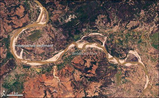
DeforestationImpervious surfaces aren’t the only way that developed landscapes contribute to flooding. Even without pavement, deforested land can no longer anchor soil, and dirt washes into rivers, filling the river bottoms with silt. A shallower river is able to hold less water, increasing the flood hazard. This impact of land use on erosion and floods can be seen in satellite imagery, says Robert Brakenridge, the principle investigator behind the Dartmouth Flood Observatory. In forest-cleared areas, “flood waters are sediment rich, and flood channels are silted in.” |
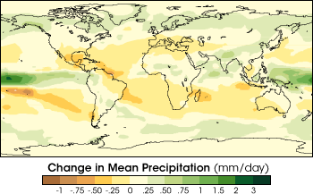
Global climate change caused by greenhouse gases is likely to shift rainfall patterns in addition to raising temperatures. This map shows computer model predictions of the difference in rainfall patterns between the thirty-year periods 2071–2100 and 1961–1990. The model predicted that green areas would receive more rainfall in 2071-2100, while orange regions would receive less. (Map courtesy IPCC Technical Paper V, Climate Change and Biodiversity) | ||
 | |||
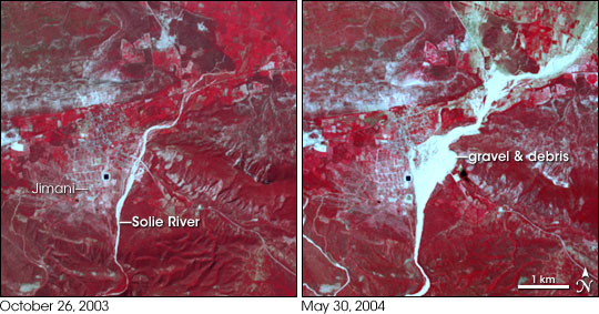
In 2004, tragic floods killed thousands of people in Haiti. Images of the flood regions taken by sensors on NASA’s Terra satellite show wide deposits of rocks and mud that washed off the bare hills and moved with the water through silted-in river channels. The images also show huge scars on the hillsides where the water cut new channels as it drained. “Such floods may have occurred in the past,” says Brakenridge, but without deforestation, “I suspect the damage wouldn’t have been as severe. You would not have debris moving with the water to block the channel capacity.” |
The Betsiboka River in Madagascar is colored reddish-brown by the silt it carries from the agricultural regions of the central highlands. Where the flow of the river slows, the sediment is deposited in the stream channel, increasing the risk of flooding. (Image by Robert Simmon, based on Landsat 7 data provided by the Global Land Cover Facility) | ||
 | |||
DroughtLand use can also exacerbate the impact of drought when water users like farmers and landscapers, power plants, and urban populations must all draw from limited water supplies. Because of this, drought can impact everything from the availability and cost of food to the cost of electricity over a wide region. When comparing single events, i.e., one hurricane compared to one drought, drought is the most expensive natural disaster. In wealthy countries with sophisticated disaster management agencies, natural disasters like drought or floods may primarily translate into economic losses, but in other regions, the effects can be far more tragic. Drought in central Africa causes famine and starvation, and it can take aid organizations several months to organize a response to such large-scale need. Floods in Southeast Asia can destroy rice crops and create food shortages for millions of people. Early notice of a developing famine or flood hazard can save both lives and money by improving planning. Satellite remote sensing can help reduce the impact and cost of natural disasters by providing responders with a timely, detailed look at affected regions that will let them target the areas with the greatest needs. |
Heavy rains on the bare mountains of southeastern Haiti on May 24, 2004, triggered a series of floods and debris flows (mudslides) that killed about 2,000 people. These images show the town of Jimani before and after the flooding. Red areas are vegetated, and light blue regions are bare or covered by roads and buildings. The eastern half of the town was completely covered in flood debris. (NASA images by Jesse Allen, based on data provided by the ASTER Science Team) | ||