The Earth Observatory has published its last Image of the Day on this website. Please join us on our new home at science.nasa.gov/earth/earth-observatory.
NASA Remote Sensing Accomplishments |
1966: Environmental Science Services Administration (ESSA) I and II gave the United States its first global weather satellite system. 1972: NASA began the Landsat series with the launch of the Earth Resources Technology Satellite 1, which was later renamed Landsat 1. 1975: The Synchronous Meteorological Satellites (SMS)-A, the first spacecraft to observe the Earth from geosynchronous orbit, and SMS-B started producing cloud cover pictures every 30 minutes for weather forecasters. 1976: Laser Geodynamic Satellite I (LAGEOS 1) provided scientists with the ability to track very precisely the movements of the Earth's surface, increasing our understanding of earthquakes and other geological activity. 1978: The Heat Capacity Mapping Mission (HCMM) satellite demonstrated the ability to measure variations in the Earth's temperature from space, paving the way for future climate studies. 1978: Seasat demonstrated techniques for global monitoring of the Earth's oceans.
TOMS image of antarctic ozone, October, 1985. White areas are high ozone levels, black areas represent low ozone. (Image by Robert Simmon) 1984: The Earth Radiation Budget (ERBE) satellite began its study of how the Earth absorbs and reflects the Sun's energy. 1991: The Upper Atmosphere Research Satellite (UARS) began its study of the chemistry and physics of the Earth's atmosphere. UARS data are used to create global maps of ozone-destroying chemicals and to understand the processes related to ozone depletion better. By 1994, UARS' comprehensive data set provided conclusive evidence that human-made chemicals are responsible for the annual Antarctic ozone depletion. 1992: Data from the U.S.-French TOPEX/Poseidon satellite began to detail the links between the Earth's ocean and climate. By 1994, TOPEX data indicated that the Earth's average global sea level had risen in the two previous years. Spring 1992: The first Atmospheric Laboratory for Applications and Science (ATLAS) flew on the Space Shuttle Atlantis. The mission carried fourteen experiments to study the chemistry of the Earth's upper atmosphere and the Sun's energy, and the effect of those two elements on ozone levels. Two additional ATLAS payloads were carried on subsequent shuttle missions in 1993 and 1994. 1994: The Space Radar Laboratory, which flew on two shuttle missions, demonstrated the uses of a complex radar to study the Earth's surface, with applications in ecology, geology, water-cycle studies, and other areas. Related research released in 1996 shed new light on the Great Wall of China and the geological history of the Nile River. 1997: The Sea-viewing Wide-field-of-view sensor, the only sensor onboard the OrbView-2 satellite, was launched into low-Earth orbit from a Pegasus rocket attached to the belly of a modified Lockheed L-1011 aircraft. Data gathered from SeaWiFS is helping scientists identify oceanic "hot spots" of biological activity, measure global phytoplankton biomass, and estimate the rate of oceanic carbon uptake. This information will yield a better understanding of the sources and sinks in the carbon cycle and the processes that shape global climatic and environmental change.
1997: NASA, along the National Space Development Agency of Japan, launched the Tropical Rainfall Measuring Mission (TRMM) from the Tanegashima Space Center in Japan. TRMM houses five separate instruments including the first-ever precipitation radar to fly in space. Designed to help our understanding of the role that the water cycle plays in the current climate system, TRMM is providing much-needed data on rainfall and the associated heat released during the condensation-precipitation process in the tropics and sub-tropics. 1999: The latest mission in the Landsat series—Landsat 7—launched from Vandenberg Air Force Base. Landsat 7 is continuing the flow of global change information to users worldwide. Scientists use the Landsat satellites to gather remotely-sensed images of the land surface and surrounding coastal regions for global change research, regional environmental change studies, and other civil and commercial purposes. 1999: The QuikSCAT satellite was launched from Vandenberg Air Force Base atop a U.S. Air Force Titan II launch vehicle. QuikSCAT houses a scatterometer called SeaWinds that is being used to acquire all-weather, high-resolution measurements of near-surface winds over the Earth's oceans. These data will be combined with measurements from scientific instruments in other disciplines to help us better understand the mechanisms of global climate change and weather patterns. Beginning in late 1999, NASA will launch the Terra satellite (formerly EOS AM-1), the flagship of the Earth Observing System (EOS)—a series of spacecraft that represent the next landmark steps in NASA's leadership role to observe the Earth from the unique vantage point of space. Focused on key measurements identified by a consensus of U.S. and international scientists, Terra will enable new research into the ways that Earth's lands, oceans, air, ice, and life function as a total environmental system. Terra is scheduled to launch from Vandenberg Air Force Base, California. next: References |
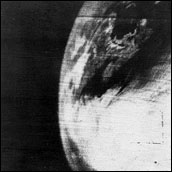
 Remote Sensing Related Data Sets: The image at upper left is the first television picture from space ever received, from the TIROS-1 satellite. (Image courtesy National Climatic Data Center) |

 Beginning with the April 1, 1960 launch of the Television and Infrared
Observation Satellite (TIROS 1), which proved that satellites can
observe Earth's weather patterns, NASA has been studying the global
perspective of our environment. Other NASA accomplishments in observing
the Earth include:
Beginning with the April 1, 1960 launch of the Television and Infrared
Observation Satellite (TIROS 1), which proved that satellites can
observe Earth's weather patterns, NASA has been studying the global
perspective of our environment. Other NASA accomplishments in observing
the Earth include: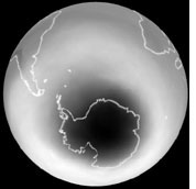 1978: Nimbus 7, the final satellite in that series, was launched
carrying a Total Ozone Mapping Spectrometer (TOMS) instrument that
provided 14 years of data on the Earth's ozone layer. Data from the TOMS
were part of the scientific basis for the Montreal Protocol and other
treaties banning the manufacture and use of ozone-depleting chemicals.
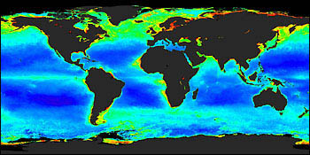
In addition, Nimbus 7's Coastal Zone Color Scanner (CZCS) obtained a
data set that is widely used to study the links between the oceans'
biology and the Earth's climate.
1978: Nimbus 7, the final satellite in that series, was launched
carrying a Total Ozone Mapping Spectrometer (TOMS) instrument that
provided 14 years of data on the Earth's ozone layer. Data from the TOMS
were part of the scientific basis for the Montreal Protocol and other
treaties banning the manufacture and use of ozone-depleting chemicals.
In addition, Nimbus 7's Coastal Zone Color Scanner (CZCS) obtained a
data set that is widely used to study the links between the oceans'
biology and the Earth's climate.