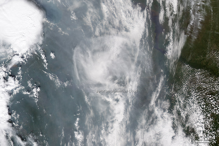

Fromm started with true-color images from the Moderate Resolution Imaging Spectroradiometer (MODIS) on NASA’s Terra and Aqua satellites. At about 7:00 UTC, a few hours before OMI made its observation, an odd circular cloud complex was visible above a field of smoke in the Terra MODIS image. The cloud was faintly tinted brown, and its circular shape was different from the long lines of clouds beneath it. Temperature measurements from MODIS also revealed that the cloud was much cooler than the surrounding clouds, indicating that it was a high-altitude ice cloud.

A circular cloud structure is the remnant of a pyrocumulonimbus cloud or firestorm that had drifted over northern Russia from fires in western Russia. MODIS on NASA’s Aqua satellite acquired this image on August 1, 2010. (NASA images by Jesse Allen and Robert Simmon based on MODIS data.)
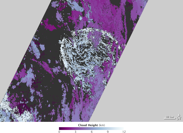
To confirm the cloud’s height, Fromm got a tip from David Nelson, a scientist from the Jet Propulsion Laboratory working with the Multi-angle Imaging Spectroradiometer (MISR), which also flies on Terra. MISR carries nine cameras that simultaneously acquire images of the Earth from nine different angles. By merging images from each angle, scientists like Nelson can get a multidimensional view of clouds and Earth’s surface. On August 1, Nelson’s multidimensional view revealed that the cloud over the Russian fires was shaped like an umbrella with a bulging top and lower edges. The top of the cloud reached 12 kilometers.

The Multi-angle Imaging Spectroradiometer confirms that the umbrella-shaped cloud reached 12 kilometers above the Earth’s surface into the lower stratosphere on August 1, 2010. (NASA image by Jesse Allen and Robert Simmon based on MISR data.)
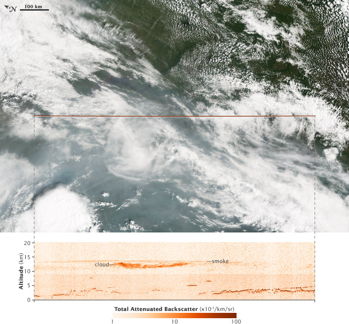
The final piece of evidence connecting the cloud to the unusual aerosols came from NASA’s Cloud-Aerosol Lidar and Infrared Pathfinder Satellite (CALIPSO). By sending a pulse of light into the atmosphere and measuring the light that comes back, CALIPSO provides a profile of what types of particles are in the atmosphere and at what altitude. Clouds return a different type of signal than aerosols because cloud particles have a different shape and size. Particles that are high up also return a signal more quickly than those closer to the ground, information that CALIPSO turns into particle altitude.
Fortunately, CALIPSO passed over part of the suspicious cloud on August 1. The sensor recorded the high, dome-shaped cloud at 12 kilometers. It also confirmed that the cloud contained more than water and ice. Smoke aerosols formed a cap over the cloud, and the air around the cloud was contaminated with smoke. The cloud, CALIPSO confirmed, was a pyrocumulonimbus.

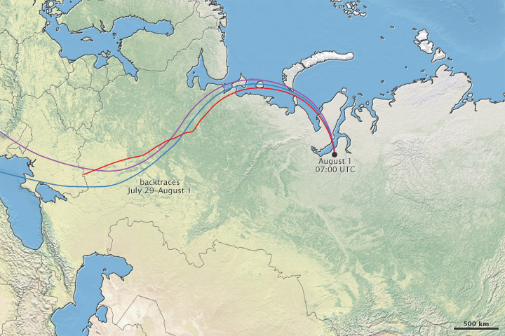
Four satellite sensors together confirmed that a pyrocumulonimbus cloud had formed and drifted over northern Russia, but where had the dangerous storm originated? By tracing the air back in time in a weather model, Fromm discovered that the air over northern Russia had traveled from western Russia. The cloud and smoke that the satellites observed had been situated over the fires in western Russia on July 30, when the fires had grown explosively. The satellites provided evidence that a firestorm helped fuel the fires’ growth.

A model containing weather data helped confirm that the pyrocumulonimbus cloud and smoke had been over fires in western Russia on July 30. The model connects the satellite observations of smoke in northern Russia to the fires in western Russia. (NASA map by Robert Simmon using NOAA’s HYSPLIT and Natural Earth.)
While pyrocumulonimbus clouds are probably not unusual, only about ten have been identified in scientific literature. As this series of images documents, pyrocumulonimbus clouds pump soot from fires high into the atmosphere. Once in the stratosphere, above the part of the atmosphere where weather occurs, aerosols can travel long distances. In this recent case, the smoke from Russian fires reached the Eastern United States. The smoke stays in the stratosphere for a long time because it is above the part of the atmosphere where weather occurs, so it doesn’t rain or fall out as easily.
The smoke aerosols are also important because of their potential influence on climate. Dark aerosols in the stratosphere absorb and reflect energy from the Sun, warming the stratosphere (which may impact our weather), while cooling the lower atmosphere. This means fires might have a slight cooling influence on the climate, similar to volcanoes. But unlike volcanoes, pyrocumulonimbus pollution of the stratosphere is not yet accounted for in climate models. Just how frequently pyrocumulonimbus clouds form and how much they contribute to aerosols in the stratosphere are questions that will require more observations to answer.
“Satellites are the key to unlocking those mysteries,” says Fromm, “and there is a multi-decade treasure of data yet to explore.”