| Data Requirements for Precision Farming | |||
According to Moran, an optimum remote sensing system for precision farming would provide data as often as twice per week for irrigation scheduling and once every two weeks for general crop damage detection. The spatial resolution of the data should be as high as 2 to 5 square meters per pixel with positional accuracy of within 2 meters. Additionally, the data must be available to the farmer within 24 hours of acquiring them. Turnaround time, she says, is more important to farmers than data
accuracy. They would gladly accept remote sensing measurements that are
as poor as 75 percent accurate if they were assured of getting them
within 24 hours of acquisition. Unfortunately, says Moran, there are
currently no Earth orbiting satellites that can meet all of a precision
farmer’s requirements. But she is optimistic that this will change
within the next 10 years as exciting new satellite remote sensing
technologies emerge. Until that time, there are still a variety of
sources of remote sensing data that farmers can use. |
|||
For instance, the Enhanced Thematic Mapper Plus (ETM+) aboard Landsat 7 and the Advanced Spaceborne Thermal Emission and Reflection Radiometer (ASTER) aboard Terra provide good spatial and spectral resolution (up to 15 meters per pixel) as well as good scientific calibration accuracy. But used by themselves these satellites’ revisit cycles are too infrequent to be of use to precision farmers. Moran is also interested in the new Advanced Land Imager (ALI) and the hyperspectral Hyperion sensor aboard the newly launched EO-1. But none of these satellite sensors have the desired temporal resolution, as they "see" a given patch of ground only once every 16 days, on average. The Moderate resolution Imaging Spectroradiometer (MODIS), aboard Terra, sees a given patch of ground almost every day (high temporal resolution), but its highest spatial resolution is only 250 meters per pixel–too coarse for precision farming but perfect for regional to global-scale research. Moran points out that precision farmers may use a combination of satellite and airborne remote sensing data to meet their needs. There are a growing number of commercial companies that serve their local regions by flying remote sensors aboard aircraft that collect data in visible and near-infrared channels at spatial resolution ranging from 0.3 to 1 meter per pixel and have turnaround times of less than 24 hours. For instance, it may be possible to purchase commercial overflights periodically during the growing season to fill in the gaps between acquisitions of satellite remote sensing data. Moran uses a computer model to integrate the various data into a simulation of the growing conditions in the field. The model allows her to overcome some of the spatial and temporal limitations in the Landsat 7 data by interpolating or predicting the changes that occur over time and space that the satellite cannot see. Ultimately, where does Moran see all this new precision farming technology heading? She envisions a day when commercial companies can serve farmers with new scientific tools that she calls "decision support systems." In much the same way banks and brokerages provide financial advice and accounting services to business persons, there will be companies using decision support systems to routinely map field boundaries as well as weed, pest, or disease outbreaks. These companies will track when a farmer plants, waters, and applies fertilizers or other chemicals. Based upon all this information, the companies will help the farmers develop good precision management strategies throughout the year to maximize their harvest yields while saving them time and money. "In a dream world, this is what should be happening," Moran muses. "That would be the entire precision agriculture application in a nutshell. We don’t yet have such a system. But do we have the technology to build one? Yes!"
|
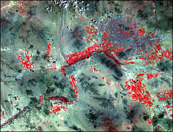
This false-color image was acquired by Landsat 7's Enhanced Thematic Mapper Plus (ETM+) in August 1999 over the Maricopa Agricultural Center in central Arizona. Bright red areas are irrigated fields. According to Susan Moran, although most satellite sensors currently lack the desired spatial and temporal resolution, they may still prove to be valuable information resources for precision farmers as these data are incorporated into better computer models that allow farmers to interpolate how growing conditions change over time and space. (Image courtesy Susan Moran, Landsat 7 Science Team) |