The Earth Observatory has published its last Image of the Day on this website. Please join us on our new home at science.nasa.gov/earth/earth-observatory.
Conclusion | |||
Today, Earth scientists' goals are to not only observe weather patterns around our world, but to determine the causes and effects of climate and environmental change. With increasingly sophisticated satellite remote sensors, we can measure a wide range of geophysical parameters (such as surface temperature, distribution of clouds and aerosol particles, the abundance of trace gases in the atmosphere, or the distribution and types of life on land and in the ocean) with unprecedented accuracy and resolution. Moreover, we can now measure how changing certain aspects of the climate system (such as cloud cover) can have a "ripple effect" through other aspects of the climate system (such as surface temperature, precipitation, the radiation budget). Scientists are feeding these new satellite data, collected throughout the Earth's climate system, into sophisticated new computer models that, ultimately, will enable them to predict climate changes months, years, or even decades before they occur. If we are to become better stewards of our home planet—if we are to leave abundant natural resources to our grandchildren and to their grandchildren—then we must continue monitoring our planet with satellite sensors ever improving our understanding of how the Earth system works.
References:
Parkinson, Claire L., 1997: Earth From Above—Using Color-Coded Satellite Images to Examine the Global Environment. University Science Books, Sausalito, CA; 175 pages. Wallace, Lane E., 1999: Dreams, Hopes, Realities—NASA's Goddard Space Flight Center, The First Forty Years. NASA History Office, Office of Policy and Plans, Washington, D.C., NASA SP-4312; 219 pages. back: From Observing to Measuring
Changes on Earth
|
 Space-based Observations of the Earth Introduction
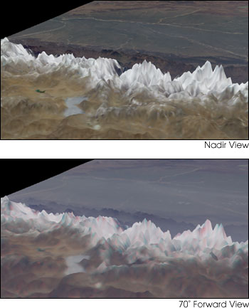
Left: This pair of views looking south from the Tibetan Plateau over the Himalayas to the Indian sub-continent shows the Earth's surface from two different angles. (Satellite data were combined with elevation data to generate the perspective view.) The top picture was taken by the Multi-Angle Imaging Spectroradiometer (MISR) as it flew directly over the terrain. The bottom picture was taken by MISR looking 70° forward. At high angles, haze and pollution scatter light very strongly, resulting in the fuzzy blue tint of the lower image. MISR will help scientists understand the role of aerosols and clouds in the Earth's climate. (Images courtesy MISR science team, NASA Jet Propulsion Laboratory.) | ||