
A Space-based Perspective | |||
 The Soviet-American race to demonstrate technological superiority yielded a fortunate byproduct for Earth scientists—a newfound perspective from which to study our world. In 1959 the Russians, again followed closely by the Americans, launched the first humans into space. Looking back, the cosmonauts and astronauts saw the Earth as a tiny oasis of life—unique, as far as we know—adrift in a seemingly lifeless sea. Against the cold, black backdrop of space, these space pioneers observed how beautiful, how warm and inviting, and yet how small and fragile our world seemed. Looking closer, they saw changes occurring—some rapidly and some slowly—all over the planet. The atmosphere seemed to almost boil with activity as clouds formed and dissipated daily. Vortices of violent storms raged across the surface. Changes on land were evident as volcanic eruptions and large wildfires sent plumes of smoke high into the atmosphere. At night, the extensive spread of humanity could clearly be seen as clusters of city lights outlining the Earth's habitable land masses. Outer space, scientists found, is an ideal perspective from which to observe and measure changes on our home planet as they happen. In April 1960, NASA launched the Television and Infrared Observation Satellite (TIROS) into a mid-latitude orbit around the Earth. Followed later that same year by TIROS II, and by TIROS III a year later, these were the first satellites designed to study Earth's rapidly changing weather patterns. They collected and beamed back to Earth thousands of images of cloud cover as well as images of hurricanes, tropical storms, and weather fronts that might have otherwise gone undetected for days using conventional methods.
Over the decades, the art and science of space-based observations of the Earth expanded and evolved. Scientists developed satellite "remote sensors" that are sensitive to regions of the electromagnetic spectrum other than visible light, allowing us to observe things we wouldn't ordinarily see. For instance, designing TIROS II and subsequent satellites to measure infrared light (basically heat) enabled scientists to produce "false color" images of clouds at night. ("False color" images are made by assigning red, green, and blue values to differing wavelengths of radiant energy.) In 1964, the TIROS design was succeeded by the more advanced Nimbus series of weather satellites, and NASA began to explore other orbit strategies for its spacecraft. The Nimbus satellites flew in near-polar, sun-synchronous orbits, allowing scientists to piece their data together into mosaic images of the entire globe.
Other satellites, such as the 1966 Applications Technology Satellite (ATS-1), flew in "geosynchronous" orbits, where they had fixed views over roughly the same spots on Earth throughout their lifetimes. The ATS-1 provided images over the same areas progressively every 30 minutes, providing meteorologists with more updates of changes occurring in near-real time. In May 1974, NASA launched the first in the series of Geostationary weather satellites, called SMS-1. In October 1975, NASA launched the National Oceanic and Atmospheric Association's (NOAA) first Geostationary Operational Environmental Satellites (GOES), each with a fixed and continuous view of the changing weather patterns beneath them. The GOES 8 and 10 satellites are still in operation, providing many of the daily weather images over North America that meteorologists display in their television evening news shows today. next: Earth is a Dynamic Planet
|
 Space-based Observations of the Earth Introduction
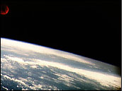
Top Left: Earth's cloudy surface, as seen by Alan Shepard onboard the Mercury-Redstone 3 (MR-3) spacecraft on May 5, 1961, the first U.S. manned spaceflight. (Image courtesy NASA Johnson Space Center) | ||