| Spotting Infection | |||
A national malaria database cannot predict all the areas that are having problems. The population in Belize, like that of most third world nations, is expanding at an exponential rate and people constantly erect new houses. Moreover, many people do not report the disease when they get sick because it is hard to diagnose on sight. To augment the database, the researchers have been working to create satellite maps of Belize that highlight the areas where the major malaria-carrying mosquitoes breed. With such maps, the government could identify regions of potential risk where there aren't many records. Since satellite maps can be updated on a regular basis, Belizians would also be able to gather information on land use, land cover, where people are and what new developments have taken place. Creating a system to map Belize's mosquito-ridden areas is far more complicated than manipulating a database. The first step involved identifying the types of environments in which each species of mosquito thrives. To find where these mosquitoes breed best, the Uniformed Services team went out into the wetlands and rivers of Belize and took samples of the various species of mosquitoes and their larvae. They looked for correlations between habitat variables, such as types of plants and water depth, and the number of mosquitoes and larvae present. Generally, the diet of the male mosquito determines the type of vegetation a species prefers. Water, shade and protection from predators are also factors. (Rejmankova et al., 1998) With the exception of one river species, the team determined where all the major malaria carriers breed. They found that Anopheles albimanus is abundant in reed marshes with flooded mats of blue-green algae. (Montgomery et al., 1996) The Anopheles punctimacula, on the other hand, breeds best in swamp forest with lots of rotting organic matter in the water. The Anopheles vestitipennis were found in both swamp forests and in reedy marshes. (Rejmankova et al., 1998) The next step was to locate these areas with a satellite imaging system. The
Uniformed Health Services team used data from Landsat 5 and the French Systeme
Pour l'Observation de la Terre (SPOT) in their work. Both of these satellites
move in approximately circular orbits nearly pole to pole around the Earth,
scanning strip after strip of our revolving planet. The SPOT satellite retrieves
images of the planet's land surfaces every 26 days, while Landsat 5 collects
images of a given location on land roughly every two weeks. These satellites are sensitive to
different wavelengths of radiant energy—ranging from visible to infrared
light—reflected and emitted off of the Earth. The
images are then radioed back to the surface in the form of data, where
Montgomery, Roberts and other researchers can extract valuable information from
them. |
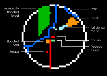
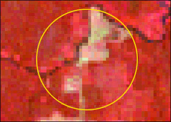
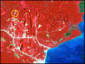 Satellite imagery allows scientists to map the environment. Regions that flood seasonally, or have standing water, are good breeding grounds for mosquitoes. The yellow circle in this Landsat image indicates an area around a cluster of houses with multiple malaria cases, and was used to generate a landcover map. (Image courtesy Uniformed Health Services) | ||
"With these satellites, [scientists] can essentially look for the reflectance values, or spectral signatures of each of the types of habitats," said Brian Montgomery. He's a remote epidemiologist at NASA's Goddard Space Flight Center who worked for Roberts during the early 1990s. In very basic terms, the researchers locate an area on an image of Belize that they know, for instance, contains marshes with blue-green algae. Using computers, they then identify those specific colors that distinguish this type of marsh or wetland from anything else covering the ground. They can then take this color combination and apply it to uncharted areas of Belize to find other reed marshes with blue-green algae. Similar classifications can be done with all the basic ground covers—cropland, urban areas, forest swamp, rivers and roads. The end result is a satellite map showing a wide range of land covers and mosquito habitats across large areas of Belize. (Roberts et al., 1996) However, alone this image would just appear to be a collage of colors covering the ground. To get an accurate mosquito habitat map with crisp outlines of swamps, villages, rivers and roads, the scientists have to combine the multi-spectral image with other sources of information, Montgomery said. The researchers bring together the imaging data along with maps of the area, aerial photographs, ground survey information and even information on housing construction. They then use GIS (Geographic Information System) software to integrate all of these layers of data to form a coherent map of the landscape, complete with the location of the villages at risk and the habitats of various species of mosquitoes. "Anyone using these maps should be able to tell with high accuracy, the precise longitude and latitude where risk for malaria is high," said Montgomery. |
The data contained in the image to the left was used to generate the map of landcover types below it. The highlighted areas (marsh, flooded forest) are likely filled with mosquitoes. Scientists use these maps to locate houses and communities that are exposed to large numbers of mosquitoes. They then know where to allocate resources for mosquiot control, including insecticides and bed nets. (Images courtesy Uniformed Health Services) |