
| Seeing the Light | |||
Urbanization in any country generally begins when large-scale commerce takes root and most new jobs are to be found in the factories and financial centers in cities. In the United States, urbanization began to occur roughly around the turn of the last century. Since then, the percentage of people living in the United States in urban areas has risen from 39 percent to more than 73 percent (U.S. Census Bureau, 1995). From decade to decade the amount of rural land that has been consumed by urbanization is enormous. Between 1982 and 1992, for instance, 19,000 square miles of otherwise rural cropland and wilderness were developed in the U.S. This would be the equivalent of covering half of Ohio into one big subdivision in a ten-year period (World Resources Institute, 1996). Urbanization is not just an issue in the United States. Right now researchers estimate that worldwide movement towards cities is growing at three times the rate of population expansion worldwide. Only a third of the planet’s population lived in urban areas ten years ago. Now that number is up to 50 percent and in ten more years roughly two thirds of humanity will live in the cities (World Resources Institute, 1996). Imhoff says that while working at Stanford University as a
post-doctorate, he initially became intrigued by the biological
implications of urbanization after he saw how urban sprawl appeared on
the Earth’s surface when viewed from orbit. "I spent a number
of years looking at the Earth from space, and I found it remarkable how
human development of land looked a lot like biological growth. Like mold
on an orange," he says. |
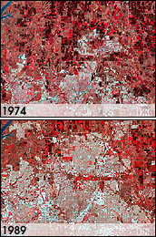
 Cities and suburban areas are growing rapidly, as shown by these two images of Plano, near Dallas, Texas. (Images courtesy USGS Earthshots) | ||
He wanted to know how urban sprawl was changing the landscape on a global scale, and whether this increased development was affecting food supplies, local ecosystems, and even the global climate. Early on, he realized that the best way to do such a study would be to construct a map of urbanization using remote-sensing data from satellites. "Satellite data would give us a synoptic view of the globe from which we could get an explicit idea of where the human-dominated surface features are – especially with respect to cities. We could also merge that information with soil maps and biosphere data from other satellites to assess the impact of urbanization on ecosystems," he says. To construct such a map Imhoff needed a satellite instrument that
would give him a snapshot of the urbanization on an entire continent all
at once. When he began this research, he had access to data from a
number of remote-sensing satellites, such as Landsat 5 and NOAA’s
operational satellites, that record the reflected sunlight and heat
emissions from the surface of the Earth. But demarcating urban sprawl
with the instruments on these satellites would require the researchers
to retrieve close-up images of cities and separate each individual,
urbanized area from the surrounding farms, parks, and wilderness. Doing
so for an entire continent would have been labor intensive and tedious. |
St. Louis, Missouri appears as a grey smudge against green woods and brown, freshly plowed fields in this early autumn satellite image. (Image courtesy Reto Stöckli and Robert Simmon, NASA GSFC) | ||
Imhoff found a solution in an unlikely place. He recounts a weekly astronomy club meeting he attended in 1996. "The people at the meeting were talking about how light pollution was a problem. They pulled out a satellite-generated city lights map. They were looking at it and saying, ‘Look at all that awful light pollution.’ And I’m there thinking, ‘This is exactly what I need. There’s my global map of where human beings are,’" he recalls. The images were taken by a Defense Meteorological Satellite Program’s (DMSP) Operational Linescan System (OLS). This network of satellites was originally designed to pick up on lunar illumination reflecting off of clouds at night in order to aid nighttime aircraft navigation. What the Air Force discovered is that on evenings when there was a new moon, the satellites were sensitive enough to record the illumination from city lights. Over a period of several new moons, the data the satellites retrieved could be pieced together to produce a global image of city lights. Imhoff explains that in the past census researchers have tried to use the city lights images to estimate the number of people in urban areas. In general they could only get a rough count simply because there was no way to tell, by looking at the lights alone, whether a very densely populated city such as Seattle had more people per square mile than a sprawling city such as St. Louis. However, Imhoff and his team were not interested in population counts. They wanted to measure the spatial extent of urbanization. For this purpose, he reasoned, the maps would be perfect. |
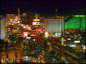
 Wherever there are cities, there are city lights. Some satellite sensors, designed to view clouds by moonlight, also detect lights on the ground. Scientists use satellite derived city light data to map urbanization. (Photo courtesy Steven Dahlman) |