The Earth Observatory has published its last Image of the Day on this website. Please join us on our new home at science.nasa.gov/earth/earth-observatory.
Reefs, Reeds, and Riverbeds
|
|
||
|
|
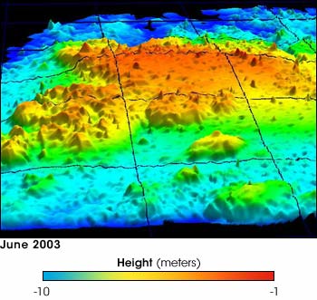
Johnson’s Reef on the northwest shore of St. John Island in the U.S. Virgin Islands forms colorful peaks in this lidar image recorded by NASA’s Experimental Advanced Airborne Research Lidar (EAARL) in June 2003. The coral reef is part of the Virgin Islands National Park. Reef managers could use such a complete picture of the shape of the reef as a standard when tracking reef health, growth, or damage. This EAARL image provides a much-needed overview. Each grid in the image covers 100 square meters of the reef. The red peaks are sections of the reef just one meter below the surface of the water. The dark blue troughs are 10 meters below the surface. Read more on Johnson's Reef. |
||
|
Despite the accuracy and importance of the information gleaned from the North
Carolina coastline, Wright almost seems to regret he couldn’t track damage in
more complicated coastal regions. If Isabel had passed through the Florida Keys,
he notes, EAARL could have seen through the clear water to chart damage to coral
reefs. Indeed, the team has already imaged coral reefs in the Florida Keys. EAARL
could also show damage to vegetation along the South Florida coast. Determining
the status of mangroves—the tropical trees that filter water for coral reefs
and provide an important habitat for fish and wildlife in tidal waters—could
have given significant insight to the overall impact of a storm. But along
the North Carolina coastline, EAARL was used primarily to chart sand transport.
The water in the mid-Atlantic is generally too murky for EAARL to assess underwater
damage like the depth of the new inlet on Hatteras Island, and there is little
vegetation on the sandy beaches for EAARL to map. |
|||
|
|
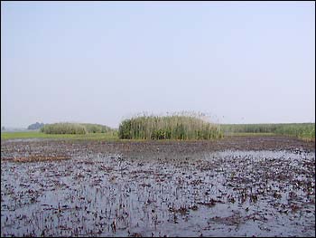
Stands of invasive Phragmites, a common reed, grow in Central Delaware. Photo courtesy Wayne Wright, NASA Wallops Flight Facility. |
||
|
Though it didn’t track the changes Hurricane Isabel wrought on plants, EAARL has already come in handy for mapping coastal vegetation. Common reeds, called phragmites, are invading eastern shores and marshes. Crowding out native plants that support wildlife such as ducks and geese, stands of phragmites grow up to six feet tall and pose a significant fire hazard. It is unclear how these European reeds came to take over US shores, but it is possible that they were stowed on boats in the late 1800s as shipping material. Now, like generals preparing for a battle, scientists want a clear picture of where these invasive plants are and how extensively they cover the coast. Wright has been flying reconnaissance with the EAARL instrument to map out stands in central Delaware. The data he collects will be used to estimate the current state of phragmite infestation and to show how effective efforts to control them have been. Such information will help the National Fish and Wildlife Service reclaim coastal marshes for native plants and animals. EAARL’s capabilities aren’t limited to what’s visible above the surface, however.
To illustrate how EAARL might be used to look for storm related damage in shallow
waters, Wright describes a water management project along the Platte River in
Nebraska. This tributary of the Missouri is typically less than a meter in depth
but several hundred meters wide and filled with meandering sandbars. Hydrologists
want to understand how these sand bars migrate along the river bed. “The
river is far too shallow for a boat and most lidars. You need a real short laser
pulse to measure the river bottom,” says Wright. EAARL has the short light
pulse needed to read the shifting sands both above and below the water. Traditionally,
hydrologists waded into the river with a GPS unit, manually recording variations
in depth. It took six to eight people an entire day to cover a single kilometer
of the river, making about 2000 measurements. At up to 5,000 measurements per
second, the EAARL instrument can do the same in less than a second. |
|||
|
|
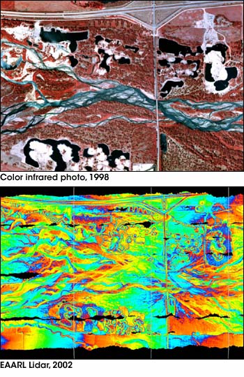
A color infrared photo (top) of the Cottonwood Ranch section of the Platte River gives an aerial view of the area shown in the lidar image (bottom). In the photo, higher elevations are white. The Overton Bridge forms a straight line over the river, and Interstate 80 runs along the north side of the river (top). The infrared photo is especially helpful in seeing where the river flows in deep channels. The photo shows channels of water in blue, while the lidar image shows the shape and depth of the channels in strips of color. Read more about the Platte River Lidar project. The photo, taken in 1998, was provided by Paul Kinzel, USGS. The lidar image, taken in 2002, was provided by Paul Kinzel and Wayne Wright, NASA Wallops Flight Facility. |
||
|
The result is breathtaking. Swirling ribbons of color resembling fire more than water mark out deeper channels in the river. Sandbars are wider, more solid areas. Since the west end of this section of the river is about 20 meters higher than the east end, a simple color bar can’t show all the subtle changes in elevation while also showing the east-west elevation change. To solve the problem, the color scale “wraps around,” that is, starting on the east (right), blue is the lowest elevation going up to red, 3 meters above that. Then, blue begins to represent 3 meters and red, 6 meters, and so forth. The effect is a rainbow of color going from east to west. Similar maps could be made of the coastline in clear, shallow waters, though in coastal waters, the changes are more dramatic, so “wrapping” the colors isn’t necessary. The purpose of the Platte River mapping project was to see if lidar data could be used to map the riverbottom at all. Paul Kinzel, a hydrologist with the United States Geological Survey and the principle investigator in the project, compared the data with handheld GPS measurements as a sort of “truth test.” He reports that the lidar measurements were within 15 centimeters of the more accurate GPS measurements, and better in shallower water. As the accuracy improves, he hopes to use lidar to measure changes to the river bottom before and after controlled releases from reservoirs. Measuring changes brought about by a man-made flood isn’t all that different than tracking storm damage along the coast. “We are interested in seeing how well the technology will perform,” Kinzel notes, referring to EAARL mapping inland rivers in general. “It’s proven that it has potential.” |
|||
| |