The Earth Observatory has published its last Image of the Day on this website. Please join us on our new home at science.nasa.gov/earth/earth-observatory.
Capricious Coastlines“If you fly along the barrier island coast, you’ll see cuts through the islands. Almost all of them are formed the same way,” Sallenger explains—by hurricanes. To understand how severe storms shape the coast, Sallenger needed accurate before and after maps. But beaches shift daily with the tides, waves, and winds, so no map would ever provide a perfectly accurate before-after comparison. He needed to make a map of the beach immediately before a major event and compare it to a map made immediately after to know what changes were caused by the storm and what occurred as a result of other natural processes. Having EAARL on standby to map out the beach just before the hurricane hit was essential to the success of the project. |
|
||
|
|
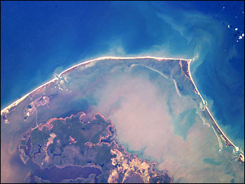
Astronauts onboard the International Space Station snapped this photo of Cape Hatteras on July 30, 2002, as they orbited the Earth. A line of islands, the largest of which is Hatteras Island in the center, form the Cape. The islands hem in the sediment-rich waters of Pamlico Sound. The narrow strips of water separating the islands were probably formed by hurricanes. Image ISS004-E-7784 courtesy of Earth Sciences and Image Analysis Laboratory, NASA Johnson Space Center. Web site: The Gateway to Astronaut Photography of Earth |
||
|
Two days before Hurricane Isabel came ashore, Sallenger and Wright collaborated to survey the areas where the storm was predicted to make landfall. “We were able to survey 250-300 kilometers of shoreline in just a couple of days,” Sallenger reports. They repeated the survey five days later to track the changes Hurricane Isabel made. Among other things, they mapped the new inlet that was cut across Hatteras Island, giving scientists the most detailed data set on storm inlets to date, says Sallenger. Those data will be used to build models of beach erosion to predict how and where inlets may form in the future. |
|||
|
|
|||
|
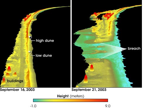
Images of Hatteras Island before Isabel show a long line of high sand dunes along the outer coast with buildings behind them. The highest sand dunes are peaked with dark orange and red to indicate elevation. The dunes in the center of the line are smaller, as is evident by their lighter tops in the image. It is no surprise then that, in the post-Isabel image taken on September 21, 2003, the low dunes have given way to the ocean. The powerful surf cut across the lowest point on the island. Below the breach, the dunes were washed away, as were a couple of the buildings behind them. Above the breach, the high dunes were worn into smaller dunes. The straight, dark stripe behind the dunes in the pre-storm image is Highway 12. Sections of the highway have clearly been washed away or covered with sand in the post-storm image. The elevation measurements in the images are amazingly accurate. EAARL measures elevation to within 10 centimeters and horizontal distance to within 40 centimeters. Its accuracy depends mostly on how well its operator knows where it is and how it’s oriented in relation to the Earth’s surface. Global Positioning System (GPS) instruments on the plane give a precise location for the system, usually to within a few centimeters—a typical thumb length. Wright then accounts for the tilt and heading of the plane—if the plane is flying level, a light shining out of the bottom will hit a different place than if the plane is banking left or right. Once he knows the precise location of the laser, Wright records the laser’s echo strength once every billionth of a second to get an accurate measurement of how far the light traveled between the plane and the ground and back again. “It’s all a matter of time,” says Wright. “Time is the critical measurement in everything that we do.” |
NASA’s Experimental Advanced Airborne Research Lidar shows where sand and buildings on Hatteras Island disappeared in the wake of Hurricane Isabel. Images courtesy Asbury Sallenger and Amar Nayegandhi, USGS Center for Coastal and Watershed Studies, and Wayne Wright, NASA Wallops Flight Facility. |
||
| |
|||