Land


Land Cover Classification
Mapping Earth's Diverse Landscapes
Differentiating Between Land Cover Types
The Basic Vegetation Map
The Problems in Uncovering Land Cover

 
pallette
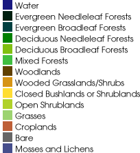
The Quicktime Virtual Reality (QTVR) movie above shows landcover over the entire globe—just click and drag on the globe to rotate it. It is based on data from the University of Maryland Laboratory for Global Remote Sensing Studies Global Land Cover Project.

 
next: Differentiating Between Land Cover Types
back: Mapping Earth's Diverse Landscapes